
If you see this above, take cover

“River in the Sky,’’ by Mo Kelman, in the group show “Luminous,” at Dedee Shattuck Gallery, Westport, Mass., Oct. 16-Nov. 14
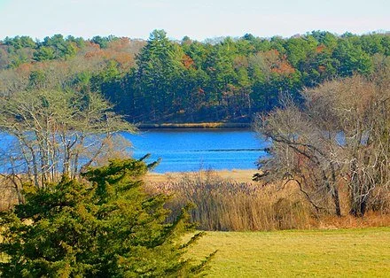
Fall on the Westport River
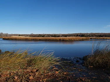
Westport River salt marshes eroding away fast
The West Branch of the Westport River.
Via ecoRI News (ecori.org)
WESTPORT, Mass. — Salt-marsh islands in the West Branch of the Westport River have declined by nearly half during the past 80 years, according to a recent report.
By studying aerial imagery of six salt-marsh islands in the river’s West Branch, scientists found that the total area of salt marshes have consistently declined during the past eight decades, with losses dramatically increasing in the past 15 years. Altogether, the six islands lost a total of 12 acres of salt marsh since 1938.
Each island lost between 26 percent and 66 percent of its marsh area, according to the 16-page study conducted by the Buzzards Bay Coalition, the Buzzards Bay National Estuary Program, the Marine Biological Laboratory Ecosystems Center, the Westport Fishermen’s Association and the Woods Hole Research Center.
If marsh losses continue at the accelerated rate observed during the past 15 years, the Westport River’s marsh islands could disappear within 15 to 58 years, according to the researchers.
“If you do a projection, it’s really discouraging,” said Rachel Jakuba, science director at the Buzzards Bay Coalition and the study’s coordinator. “The salt-marsh islands that are currently a characteristic feature of the Westport River could be gone in 50 years.”
Salt marshes are highly productive ecosystems that filter out pollution, provide habitat for wildlife and protect homes from flooding. More than half of commercial fish species on the East Coast use salt marshes for some part of their lives.
The study didn’t find a single cause of the accelerating loss of salt marshes, but cited nitrogen pollution and sea-level rise as two key factors. Dredging projects, erosion from large storms and grazing from crabs may also further increase losses.
Nitrogen pollution is increasingly being identified as a cause. Long-term data collected through the Baywatchers monitoring program show that the Westport River suffers from too much nitrogen pollution, with the largest source being residential septic systems. Although nitrogen pollution fuels the growth of plants, it can also cause the underground root network of salt marshes to become sparse and weak.
By examining samples of marsh plants and sediment, scientists found a relatively low ratio of underground roots and rhizomes to above-ground plant parts at all six islands. This low “roots-to-shoots” ratio suggests that all of the river’s salt-marsh islands are affected by nitrogen pollution, according to the report.
“Nitrogen concentration in the water is one factor that can contribute to marsh deterioration and loss,” said Linda Deegan, senior scientist at the Woods Hole Research Center and the Marine Biological Laboratory Ecosystems Center.
In an experiment she conducted in the Plum Island estuary in northeastern Massachusetts that began in 2003, Deegan and her colleagues found that long-term exposure to high concentrations of nitrogen in the water caused marsh plants to produce fewer roots and decomposition to increase, which led to marsh loss.
“The low roots-to-shoots ratio finding in the Westport River is very similar to our experimental results in Plum Island,” she said.
As sea-level rise accelerates, salt marshes are at risk of drowning from the rising waters. Of the six salt-marsh islands studied, the island with the lowest elevation lost the greatest number of acres since 1938, whereas the two islands with the highest elevations lost the fewest.
“The lowest elevation islands are the most vulnerable to effects of accelerating sea-level rise, but marshes on these islands also receive the most nitrogen from contact with flooding tides,” said Christopher Neill, senior scientist at the Woods Hole Research Center and former director of the Ecosystems Center at the Marine Biological Laboratory. “We strongly suspect these multiple stresses likely combine to accelerate marsh disappearance in many places.”
In addition to field work, the study analyzed at least nine aerial images of each salt-marsh island from 1938 to 2016. Using specialized mapping software, researchers determined how many acres of marsh existed in each aerial image to measure loss over time.
“We were able to ‘go back in time’ and look at changes over the decades at a level of detail that few people have,” said Joe Costa, executive director of the Buzzards Bay National Estuary Program. “Over time you can see tide pools forming on top of the marsh and growing, and you can see the boundaries of salt-marsh islands receding.”
Marsh loss isn’t unique to the Westport River. Marsh loss has been observed in other rivers, harbors and coves around Buzzards Bay and along the entire East Coast. The findings in Westport could be an indicator of the future of salt marshes throughout southeastern Massachusetts.
“Global climate change, exacerbated by nitrogen pollution from local wastewater sources, is having real effects here in our backyard on Buzzards Bay,” said Mark Rasmussen, president of the Buzzards Bay Coalition.
Frank Carini: Dog-poop pollution in the Westport River
WESTPORT, Mass.
Unlike many New England rivers, the one that shares a name with this popular summer town doesn’t have a legacy of industrial pollution buried in its sediment. But despite not being polluted with toxins from long-since-gone jewelry makers and dye manufacturers, the Westport River and its watershed still face the threat of contamination from stormwater runoff, nitrogen-rich fertilizers, failing septic systems and outdated cesspools.
In fact, one of the more commonly seen but often ignored threats — unless you happen to step in it — to this two-pronged river and its economically vital watershed is waste left on the ground by inconsiderate pet owners. While certainly not on the order of concern of, say, carbon pollution, the Environmental Protection Agency (EPA) does label dog waste a “pollutant.”
Sorry, Snoopy, but dog poop is 57 percent more toxic than human waste, according to the EPA, and can harbor bacteria and parasites that cause illness in humans.
This waste problem is so rampant in dog-friendly Westport and the surrounding area that the Westport River Watershed Alliance (WRWA), the nonprofit protector of the this important natural resource, was compelled this year to print a two-fold brochure entitled “The Shocking Truth About Your Dog’s Poop.”
“Even the smallest amount of dog poop is filled with bacteria,” said Roberta Carvalho, the WRWA’s science director.
It has been estimated that an ounce of dog waste can contain 650 million fecal coliform bacteria. The EPA has estimated that two to three days’ worth of dog poop from a neighborhood with about a hundred dogs would contribute enough bacteria to temporarily close a bay, and all watersheds within 20 miles of it, to swimming and shellfishing.
In 1976, the Westport River Defense Fund was created in opposition to a septage lagoon proposed by the Board of Health that would have been built near the East Branch of this tidal river. The idea to construct a sewage pit by the river to dispose of the town’s septage pump-outs created a major controversy, and resulted in what is now the WRWA.
“It didn’t happen,” Carvalho said. “It was our first victory.”
Since that battle nearly four decades ago, the Alliance has grown from 15 members to more than 2,000. Numerous projects have been developed over the years that promote education and advocacy — all in an effort to protect one of the region’s most significant coastal assets in both habitat quality and scenic beauty.
But the fact that 23 percent of shellfish beds in the Westport River are permanently closed for harvesting documents the continued problem of contamination, according to Carvalho.
In all, some 50 percent of the river’s total shellfish beds are seasonally or conditionally closed, and 76 percent of the river’s harvest potential is limited because of bacterial pollution, according to the WRWA..
“The river has gotten much better in the past 10 years, but nitrogen pollution, runoff and septic systems are still a concern,” said Carvalho, who has been with the organization for 13 years. “It’s a costly endeavor, but it is vital we protect our water resources.”
Nutrient loading and pathogen contamination are water-quality concerns, particularly in the upper reaches of the river’s 35-mile shoreline. The river suffers from the problem of eutrophication, especially in the upper East Branch. Carvalho also is concerned about the emerging threat of chemicals from personal-care products and pharmaceuticals. In addition, she believes Massachusetts needs to do a better job phasing out antiquated cesspools and replacing them with modern septic systems or municipal sewer. Westport, for one, doesn’t have public sewer.
WRWA staffers work with local schools to educate students, from kindergarten through high school, about the importance of protecting the watershed, and the organization has partnered with municipal and state agencies to run water-quality programs. The nonprofit also promotes the use of buffer strips, rain gardens and low-impact development technologies to help keep the river and its watershed clean.
WRWA has maintained a summer bacteria-monitoring program for the Westport River since 1991, and the organization’s collection and analysis of site samples has been used by municipal and state agencies to document bacterial contamination.

The Westport River watershed spans two states, Massachusetts and Rhode Island.The watershed
The Westport River has two branches. The smaller West Branch is about 7 miles long, rising from a confluence of brooks near the village of Adamsville, R.I. The West Branch separates the village of Acoaxet from the rest of Westport — one needs to pass through Rhode Island to reach the rest of the town.
The larger East Branch is about 11.5 miles long, rising at the border of Westport and Dartmouth, at Lake Noquochoke. After a short length, the river meets Bread and Cheese Brook before reaching the head of Westport village, where the WRWA will soon move into its new home. From there, the river continues southward, fed by several brooks, before an initial widening to between 100 and 400 yards at Widows Point.
Once in Westport Harbor, the combined branches bend around Horseneck Point, before flowing into Rhode Island Sound, just west of Horseneck Beach State Reservation, at the point where Rhode Island Sound meets Buzzards Bay.
The Westport River watershed encompasses parts of Westport, Dartmouth, Fall River and Freetown, and Tiverton and Little Compton in R.I., and 85 percent of the watershed’s landmass drains into the river’s two branches.
Frank Carini is editor of ecoRI News, where this piece originated.