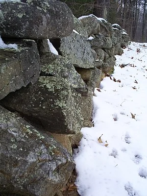
Stone wall at what had been Robert Frost's farm in Derry, N.H., a wall he describes in his famous poem "Mending Wall".
From Robert Whitcomb’s “Digital Diary,’’ in GoLocal24.com
The Concord (N.H.) Monitor ran an intriguing story on Jan. 15 headlined “Crowdsourcing New Hampshire’s love affair with stone walls’’. Stone walls, built mostly by English colonists and their descendants, most of them farmers, from the 17th to the early 19 centuries, are one of our region’s most beloved features – and a reminder of how hard earlier New Englanders had to work to wrest a living from a rocky soil.
The Monitor’s David Brooks reports how an aerial mapping system called LIDAR has eased the mapping old stone walls, many hidden in woods that have long since enveloped open fields. “The state has uploaded a zoomable image of most of New Hampshire taken by airplanes using LIDAR, which operates like sonar but uses light waves and produces a more detailed image,’’ even from a mile in the air.
“Members of the public can search through the black-and-white image and if they find what appears to be a stone wall, notable for unnatural straightness amid meandering hills or streams, they can mark it with a drawing tool that creates a thin pink line. These lines will create a map and database of the state’s stone walls. The online map includes a ‘progress to date’ link keeping a running tally of how many miles of walls have been marked.”
The project could improve our understanding of land-use patterns that developed since Europeans started to move en masse into New England. It’s always useful to know where we’ve been, which can help tell us where we’re going.
To read Mr. Brooks’s story, please hit this link.