

Bridge bathos and beauty

Cape Cod Canal Railroad Bridge, in foreground, and Bourne Bridge in December 1935 after soon after they were completed. The Sagamore Bridge is out of sight here.
Adapted from Robert Whitcomb’s “Digital Diary,’’ in GoLocal24.com
Most readers have driven on the two vehicle bridges – the Sagamore and Bourne -- over the spectacular Cape Cod Canal and noticed that the Feds built them both in only two years – 1933-1935 – with equipment and building materials inferior to what we have now. The current bridges have been impressively sturdy, though driving on the two-way spans, with their too-narrow lanes, can be unnerving. Clench your teeth and look straight ahead!
There’s also the Cape Cod Canal Railroad Bridge, also built in 1933-1935, allowing a bit of freight and seasonal passenger service on the Cape.
So the decision has been made to replace the bridges, via a combination of federal and state money. Officials say that construction of the new Sagamore Bridge won’t start until 2027 and building of a new Bourne Bridge until 2029. The hope is to complete the Sagamore Bridge by 2034 and the Bourne Bridge maybe by 2036. The total cost is projected to be $4.5 billion.
(Who of us old folks will be around to see the new bridges, and would we be too decrepit to drive on them? Would the new bridges make things, worse, not better, traffic-wise, by drawing even more people to the Cape?)
It’s very difficult to do big projects in America because of too many sometimes conflicting jurisdictions, too many permitting layers and the sometimes paralyzing fear of litigation. It would be nice if officials used the new bridges as a nation-leading example of how to speed up big projects.
I also thought of how more railroad service to the Cape would help cut down on what is often from May to October’s horrific car traffic going to and from what is a man-made island.
Likewise, Aquidneck Island would be more habitable if a railroad(s) – MBTA and/or Amtrak -- connected it with the outside world and took a lot of vehicles off the road. New bridges would, of course, be needed. The terminus would be at Thames Street in Newport, whence tourists could easily walk to many of the City by the Sea’s famous sights and sites. Alas, that’s more billions of bucks!
‘It would be energizing and uplifting if the new bridges we do put up in such watery places as Rhode Island and Massachusetts were more than just for vehicles. They could be lively attractions, providing dramatic views for pedestrians and bicyclists. There could be plantings on them and maybe even snack bars. They could become like public squares, albeit with anti-suicide fences….
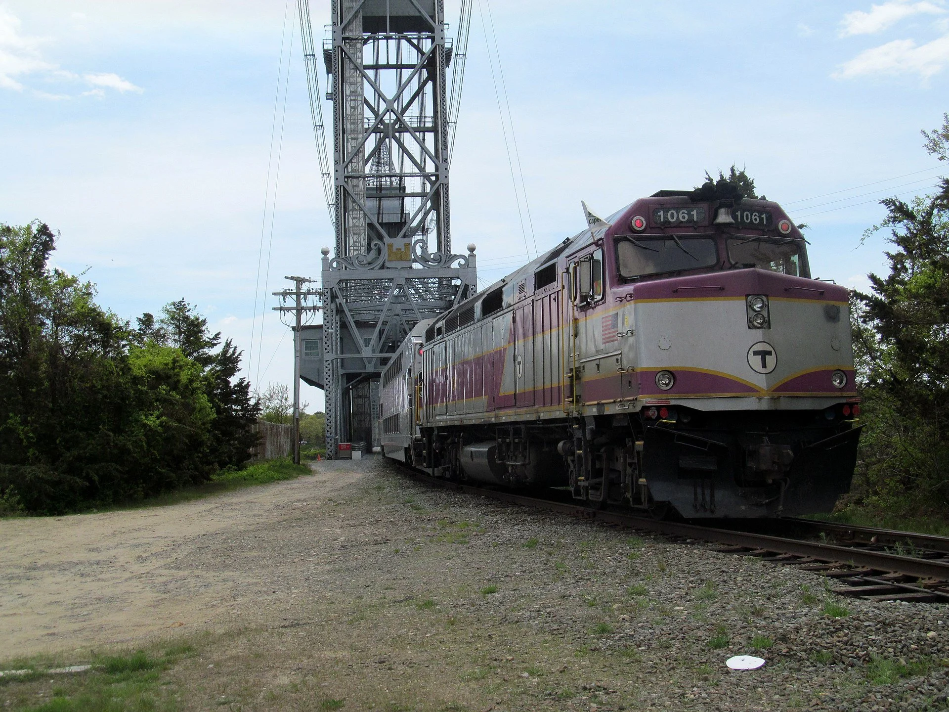
A CapeFLYER train, providing seasonal service, crosses the Cape Cod Canal Railroad Bridge on the Cape Main Line in 2013.
— Photo by Pi.1415926535

Rescue the Cape by rail
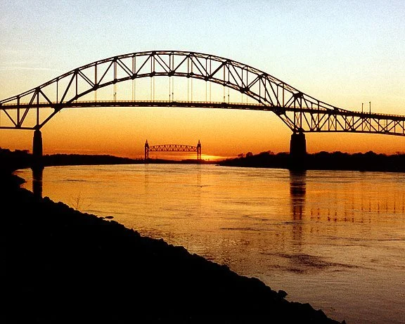
The Bourne Bridge, over the Cape Cod Canal, with the Cape Cod Canal Railroad Bridge in the distance. The Bourne Bridge mostly serves drivers coming from the west.

The Sagamore Bridge, which mostly serves drivers coming from the north, especially from Greater Boston
— Photo by Matt H. Wade.
Adapted from Robert Whitcomb’s “Digital Diary,’’ in GoLocal24.com
The narrow Bourne and Sagamore bridges, the only ways to drive to and from Cape Cod, were built back in the ‘30s and need to be replaced; they’re approaching being dangerous to drive on. Massachusetts Department of Transportation experts like the idea of replacing them with two sets of twin bridges. From an engineering standpoint, that sounds like a good idea. Let’s hope that adequate federal funds will be made available to do this.
But it’s unlikely that the new bridges would reduce traffic congestion on the Cape itself. Indeed, they could increase it by “smoothing” traffic over the canal, thus sending more drivers onto the skinny peninsula’s Route 6 (one long parking lot on summer weekends) and Route 28, some of whose traffic goes to ferry service to Martha’s Vineyard and Nantucket. (We generally stay away from the Cape from Memorial Day to after Labor Day, though we have a few relatives there.)
What would help save what’s left of the fragile, overbuilt, now mostly suburban Cape Cod is much more passenger rail service as an alternative to driving, including train stations close to the most popular summer places.
Let’s hope that whatever replacement spans go up are beautiful, befitting the spectacular setting of the world’s widest sea-level canal, with its dramatic bluffs.
‘Twists and turns’

The East End of the Cape Cod Canal and Scusset Beach State Reservation
“I could not paint a better picture,
Than the one in front of me,
Of twists and turns of the canal,
Bordered by endless trees. ‘‘
— From “Herring Run at the Cape Cod Canal,’’ by Judith Kerttula
Third Cape Cod Canal road bridge too much

The Bourne Bridge and the Cape Cod Canal Railroad Bridge
From Robert Whitcomb’s “Digital Diary,’’ in GoLocal24.com
’m glad that the Army Corps of Engineers decided against proposing a third bridge over the Cape Cod Canal, though some folks in the tourist trade liked the idea. The already overdeveloped and fragile Cape doesn’t need more cars funneled onto the long, narrow (and washing away) glacial moraine.
The corps does propose replacing the deteriorating Bourne and Sagamore bridges, which were built in the ‘30s. The new bridges would include four travel lanes, two added lanes for merging traffic, and – praise be to God! -- a median separating the on-Cape and off-Cape-bound traffic on each bridge. The lack of a median has added a certain frisson to driving over the New Deal era spans, especially as tank-like SUV’s, which always seem to be speeding, plow across.
Also encouraging is that there will be improved access for bike riders and pedestrians to enjoy the dramatic views of the world’s largest sea-level canal, with steep, wooded bluffs plunging down to it. The current structures would remain in service until the new bridges open to traffic.
The Cape needs more rail service (including railroad stations) as an alternative to cars. So I’m glad the quaint, vertical-lift railroad bridge, also put up in the ‘30s, at the western end of the canal, is not being torn down; it’s said to be in good condition.
Wider Cape highway bridges would bring more traffic

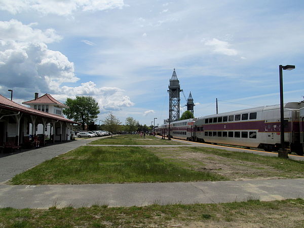
If only more people could take the train to Cape Cod, via the Cape Cod Canal Railroad Bridge, above, on such services as the CapeFLYER, seen below at Buzzards Bay.
From Robert Whitcomb’s “Digital Diary,’’ in GoLocal24.com
There are big plans afoot to replace the Bourne and Sagamore bridges, over the Cape Cod Canal, with wider ones, with the hope of easing the flow of traffic, especially, of course, in the summer, and making the crossings safer. There would be an additional third lane in each direction on each bridge. In fact, after a while the wider bridges would be as jammed as the current thrillingly narrow ones, which were built in the 1930s. More roads and lanes draw more cars.
If only there were daily, year-round train service to get more Cape-bound people off the road.
There is CapeFLYER’s Boston to Cape Cod passenger train service, over the canal’s railroad bridge, offered Friday evenings, Saturdays and Sundays from Memorial Day weekend to Labor Day. It goes from Boston’s South Station to Hyannis via Braintree, Brockton, Middleborough/Lakeville, Wareham Village, Buzzards Bay and Bourne, with scheduled travel time from Boston to Hyannis (the Cape’s Los Angeles) of 2 hours and 20 minutes. But much more train service is needed to reduce the traffic on and approaching the highway bridges.
James P. Freeman: Mogul August Belmont Jr. and the digging of the Cape Cod Canal


The Bourne Bridge over the Cape Cod Canal, with the Canal Railroad Bridge in the distance.
This article first appeared in Cape Cod Life.
August Perry Belmont Jr. was a product of his age, in an age that needed his products.
The Gilded Age—a period roughly from post-Civil War Reconstruction (1865) up to the first Progressive Era (early 1900s) was marked by energetic entrepreneurship, industrial vitality, technical invention and innovation. Commerce was transformed by new developments in steel, petroleum, electrification, transportation and finance. Engineering advances produced the transcontinental railroad, the telephone and the light bulb. New technologies yielded elevators, skyscrapers, trolleys, subways, bridges and canals.
With little regulation and fierce allegiance to laissez-faire capitalism, vast monopolies and interlocking trusts were created by such titans as John D. Rockefeller, Andrew Carnegie, Cornelius Vanderbilt and J.P. Morgan.
Nearly forgotten is August Belmont Sr. Belmont was among the defining figures of the Gilded Age. He emigrated from Prussia in 1816 and later founded August Belmont & Company, a Wall Street firm. He was a fixture of New York’s high society and his lavish lifestyle reportedly was the inspiration for Edith Wharton’s The Age of Innocence (1920). By the time of his death, in 1890, he left the huge sum for the time of $50 million to his wife and four surviving children.
Belmont’s second son, August Belmont Jr., was a builder and financier. He built New York City’s first subway route (Interborough Rapid Transit) in 1904 and was a major figure in thoroughbred racing (New York’s Belmont Racetrack). He also served as a major in the U.S. Army during World War I, in his 60s. But, arguably, Belmont’s crowning achievement was the Cape Cod Canal.
In Images of America: Cape Cod Canal, Timothy T. Orwig wrote that the need to find a shortcut across Cape Cod was “ancient.” Given its treacherous currents and shifting shoals, passage around the Outer Cape was fraught with danger and known as the “Graveyard of the Atlantic.” Ever since the Sparrowhawk went down in 1626 off Orleans, over 2,700 wrecks and 700 lost lives have been recorded around the Cape, Martha’s Vineyard and Nantucket. Not to mention untold tonnage in cargo.
As early as 1623, Miles Standish, military leader of Plymouth Colony, advocated building a canal. In 1697, a Massachusetts General Court resolution called for “a passage [to] be cut through the land at Sandwich from Barnstable Bay.” Remarkably, in 1776, George Washington authorized the first of many surveys to consider the feasibility of such an undertaking. And by the late 1800s, President Chester Arthur saw the prospect of a canal as a military asset and considered coastal waterways among his highest priorities.
Nevertheless, nearly three centuries of legislative ineptitude combined with virtually no heavy industry, made the project impossibly impractical. That is until the early 20th Century saw a coalescing of financial power, industrial power and will power.
Technically, a crude canal had already sliced through the peninsula. That distinction belonged to what was known as “Jeremiah’s Gutter” (also known as “Jeremiah’s Dream” and “Jeremiah’s Drain”). It formed naturally after The Great Storm of 1717 and made travel between Orleans Town Cove (fed from the Atlantic Ocean) and Eastham’s Boat Meadow Creek (fed from Cape Cod Bay) possible. In 1804 a canal was first dug over this periodically flooding lowland owned by Jeremiah Smith. According to Robin Smith-Johnson, in Cape Cod Curiosities, “It was also used as an escape route by local boatmen in the War of 1812.” But by 1817, 100 years later, it was effectively impassable.
Belmont was perfectly suited for the gargantuan task at hand. Construction of the new canal was a personal as well as professional endeavor for him. Author and historian J. North Conway makes the connection in his wonderfully engaging book, The Cape Cod Canal: Breaking Through the Bared and Bended Arm.
While Belmont was motivated by profit—improving transport of raw materials and finished products in and out of New England via shipping through a toll canal—he had personal ties to the Cape, despite his New York roots. “Part of Belmont’s… reason for involving himself in the digging of the Cape Cod Canal,” writes Conway, “was due to his deep affection for his maternal grandfather, Commodore Matthew Perry, who lived on Cape Cod.” Perry is credited with opening trade with Japan to the West in 1854. So it was appropriate that the ceremonial first shovelful of earth marking the start of the Cape’s Big Dig occurred on June 22, 1909 at the Perry farm in Bourne.
The sheer scale of the undertaking and associated disruption was not without controversy. Harper’s Weekly in 1908 lamented that “the new conditions which must prevail on the peninsula will cause the disappearance of the simple and unaffected people.…” The magazine did recognize that “40,000 vessels pass around the Cape annually… while only between 3,000 and 4,000 ships traverse the Suez Canal during the same length of time.” A year and a half later, the same publication wrote more approvingly of “The Conquest of Cape Cod.” Shortening the trip by 74 miles between Boston and Southern ports, “it is in the saving of lives, ships and cargoes that the canal will be chiefly valuable.”
Belmont, like other businessmen of his day, insisted that the project not involve government intervention. His chief engineer, William Barclay Parsons (Belmont’s engineer for the New York subway and a member of the Panama Canal Commission), underscored such sentiments before the Boston Chamber of Commerce in May 1910. “This is a private enterprise,” Parsons said, “supported by private capital invested under a state charter… asking for neither federal, nor state, nor municipal aid.” And it should come as no surprise that Belmont employed Gilded Age financing structures to make the canal a reality. His Boston, Cape Cod and New York Canal Company bid out a contract to build the canal. Cape Cod Construction Company was the winner: a company controlled by Belmont.
The Bourne Bridge was finished in May 1911 followed by the Buzzards Bay Railroad Bridge (November 1911) and Sagamore Bridge (February 1913). An engineering and picturesque marvel spanning 13 miles, the new canal was 25 feet deep and roughly 125 feet wide. It cost over $11 million to build. Over 16 million cubic yards of sand, stone, clay and glacial boulders were removed. And six men lost their lives.
The new waterway opened to great fanfare in a ceremony on July 29, 1914. Among the dignitaries in attendance was Assistant Secretary of the Navy Franklin Delano Roosevelt. Even President Woodrow Wilson wrote a “hearty congratulations.”
World war and a new progressive direction in America changed everything. Just the day before the grand opening, Austria-Hungary declared war on Serbia, leading to World War I. At President Wilson’s direction, the United States Railroad Administration took control of the canal in July 1918. After the war, in April 1919, the government filed a petition to begin condemnation proceedings to formally acquire the canal.
August Belmont Jr. died in December 1924. After years of legal, political and financial haggling, the sale of the Cape Cod Canal took place in April 1928. The Belmont estate received a mere $4.5 million in proceeds. And based upon Belmont’s overall investment, J. North Conway estimates the estate lost nearly $5 million.
Congress gave authority to the United States Army Corps of Engineers to take over operation and maintenance of the canal. Work began to effect badly needed improvements: widening and deepening the canal, and constructing new bridges. The modernization of the Cape Cod Canal became a public-works program. Leisure would complement commerce. A sprawling federal government acted like a die grinder to temper the sharp edges of the Gilded Age. Power shifted away from unbridled titans to Washington bureaucrats.
The new and improved canal was squarely a byproduct of progressive policies put into place during the Great Depression. Such New Deal programs as the Public Works Administration, Emergency Relief Act and Rivers and Harbors Act in the mid-1930s helped finance the $37 million cost. Several hundred workers helped build the two distinctive vehicular bridges and unique vertical-lift Railroad Bridge, still standing and functioning 84 years later. Toll free.
Perhaps fittingly, a black and white postcard of the sparkling new Sagamore Bridge dated June 22, 1935 (the official dedication of the rebuilt canal) noted that “Mrs. August Belmont parted the ribbon.”
Mark Twain’s novel The Gilded Age: A Tale of Today was a biting satirical commentary about a by-gone age. His work exposed the appearance of gross materialism, political corruption, corporate greed and widening social inequality just beneath the surface of glossy, heady progress.
Twain actually traversed Cape Cod before Belmont’s canal became reality.
“‘This, gentlemen,’ said Jeff, ‘is Columbus River, alias Goose Run. If it was widened, and deepened, and straightened, and made, long enough, it would be one of the finest rivers in the western country.’”
James P. Freeman is a New England-based columnist and financial adviser and a former banker.

The drawbridge over the canal that was replaced by the Sagamore Bridge.
Bigger bridges, bigger traffic

The Bourne Bridge and the Cape Cod Railroad Bridge in the sunset.
From Robert Whitcomb’s “Digital Diary’’ in GoLocal24.com
The Feds are considering replacing, in the next few years, the two highway bridges – the Bourne and Sagamore (there’s also a quaint railroad bridge) over the Cape Cod Canal, necessitating mini-Big Dig construction on the approaches on each side of the canal. Each new bridge would, as with the bridges now, have two lanes in each direction, but with an additional lane at each end to, it is hoped, ease merging.
Prepare for massive summer traffic jams during construction, when, you’d hope, the two existing bridges, built in the Depression, would continue to be open.
But get ready for even bigger summer traffic jams than now after the “improvements’’. Highway expansions quickly serve to lure more traffic, in a variant of Parkinson’s law: Expenditure rises to meet income. The fragile, eroding, increasingly suburbanized giant sandbar will get chewed up even more by development. And officials of its towns will probably feel compelled to widen local roads to deal with more cars coming over the bridges.
Far better if a lot of people could travel to and from the Cape by train. And how about, for example, trains to take people to Woods Hole and Hyannis to meet the ferries to Nantucket and Martha’s Vineyard?

My Cape Cod -- from rural to suburban

The Bourne Bridge, over the Cape Cod Canal, with the Cape Cod Canal Railroad Bridge in the distance.
From Robert Whitcombs's "Digital Diary','' in GoLocal24com
We went down to the Cape the other day to stay with a cousin in a house on a harbor on Buzzards Bay. I thought of how much the Cape had changed since my boyhood, in the ‘50s. Then, much of it was truly rural, with small farms and many cranberry bogs. There were no superhighways. Approaching from Boston’s southeastern suburbs, you’d go down Route 3A, which would become increasingly rustic as you headed south, with farm stands and general stores. The closer we got to the Cape Cod Canal, the more the air smelled like pine, as we entered a state forest.
Then the excitement of crossing the Sagamore Bridge onto an island/peninsula then devoid of big box stores, malls and gated retirement communities and on to my paternal grandparents’ gray-shingled house in the village of West Falmouth, the land of which some of my Quaker ancestors had bought from the Indians in the 1600’s. Then, if there were still time, to the beach, where the water was much cleaner and warmer than in Massachusetts Bay, and where the private bathhouse would get destroyed from time to time in hurricanes, to whichBuzzards Bay is particularly vulnerable.
After that, getting some ice cream from the village’s one and only general store. Then maybe a trip to Woods Hole the next day to see the aquarium of the world-famous Oceanographic Institution there. Woods Hole was where some of my ancestors built boats and partnered in the Pacific Guano Co., where bird excrement from Pacific Islands was processed with fish meal to make what was considered in the 19th Century the best fertilizer. Nowadays, it’s hard to think of Woods Hole as a factory town. Rather, it’s now in effect a college town.
As for West Falmouth, while it’s still almost as pretty as it was 60 years, it’s a ghost town to me since virtually everyone I knew there has died or otherwise gone elsewhere.
Or we occasionally approached the Cape from the west, on Route 6, with its strips of clam shacks, cheap motels and kitschy tourist-oriented gift stores. Ugly, but delightful to young children. Now, of course, you miss the local and often tacky texture on the boring big divided highways. And these highways draw in so much out-of-region traffic that the traffic jams on the two road bridges (there’s also the beautiful railroad bridge) mean driving to the Cape can take considerably longer now than in the ‘50s.
Because of that and because too much of this glacial moraine now looks like exurbia or suburbia, we don’t makemany visits anymore to Olde Cape Cod. Still, the air down there still has a certain luminosity.
Looking at a new bridge over Cape Cod Canal
By JOYCE ROWLEY, for ecoRI News Due to a typographical error, Route 6 was rendered Route 9 in an earlier version of this article. This is the corrected version.
As summer visitors to Cape Cod fume in gridlock 10 miles long, it may help to know that state, federal and local planners are trying to do something about it.
It’s long been a problem getting on and off the Cape on any summer weekend — so much so that locals have a tradition of standing on the bridges at the end of Labor Day weekend and waving goodbye as summer guests leave. For them, the end of the summer means being able to cross the canal freely.
But lately, even spring and fall sees its share of traffic snarls. The Sagamore and Bourne bridges turned 80 last week. Completed in 1935 under the Works Progress Administration and now owned by the Army Corps of Engineers, maintenance is an ongoing problem.
With only 10-foot-wide travel lanes and no breakdown lanes, maintenance work on either one of the bridges requires lane closures. That work can’t be done during the summer, because of a fourfold increase in traffic volumes over both bridges. Therefore, maintenance is done during “shoulder” seasons — March through May and September through November.
“Everyone is saying, ‘You have to do something about the bridges, you have to do something about the bridges,’” said Glenn Cannon, transportation planner for the Cape Cod Commission. “There’s a significant disruption of residents’ lives with lane closures.”
Cannon said there are people who don’t even try to leave the Cape on summer weekends. Bourne residents, whose town straddles the Cape Cod Canal, are now loathe to go to Town Hall on a Friday because of the long return trip through tourist traffic.
In 2013, Massachusetts Department of Transportation (MassDOT) created the private-public partnership (P3)Project SPAN that will select a private firm to finance, design, build, operate and maintain a third bridge over the canal. Last fall, Project SPAN kicked off with an industry tour, as MassDOT brought in engineers and developers from all over the country.
This year, MassDOT launched the Cape Cod Canal Transportation Study to explore the environmental issues associated with building a new bridge. A 30-member working group made up of state, federal and local stakeholders augments public-input sessions. Consulting groups Fay, Spofford & Thorndike and The Cecil Group are providing an engineering assessment of the project.
“The two projects are running concurrently,” said Bob Frey of MassDOT’s planning division. “The canal area study is one of our typical corridor planning studies. It will also be more comprehensive than the P3 study.”
Frey said the canal study is trying to address the future of the existing bridges. The P3 alternatives for either a mid-Cape bridge or a second bridge near the Sagamore are just two of an array of alternatives the study will evaluate. Having the Army Corps of Engineers in the mix changes things considerably, he said.
The Army Corps is responsible for bringing both bridges up to modern standards — 12-foot lane widths, shoulders and safe accommodations for bicycles and pedestrians. Those changes would greatly improve traffic flow, but the cost would be significant — about $320 million per bridge.
“In general, there is support for replacing existing bridges among the residents,” Cannon said. The problem, he noted, is that the bridges are structurally sound, although functionally obsolete.
“It’s a matter of perspective,” Cannon said. “From the Army Corps’ perspective, there's no justification for replacing the bridges. Their responsibility is to the shipping traffic underneath.”
He said the Cape Cod Commission has put a lot of projects on hold to see whether new bridges will be built.
“A new crossing could have major impacts to other ongoing projects,” Cannon said. “They could bypass the Belmont Circle in Bourne. A fix could alleviate the traffic problem there and decrease the cost of the project. It could become a pedestrian accommodation and improved pedestrian crossings.”
Choke points “If you accept that the choke points are the bridges, then what are the conditions on the existing roads?” asked Ed DeWitt, executive director of the Association to Preserve Cape Cod.
By moving a single bottleneck, DeWitt believes the merge on eastbound Route 6 at Exit 6 on the Cape will still back up. “The highway and road system across Cape Cod will still have problems.”
DeWitt supports replacing the bridges through a process called “twin spanning.” He points to Connecticut as leading the way in this method of building a new bridge with modern standards next to an existing bridge, then switching the traffic over and replacing the old bridge, to minimize traffic disruption.
But the problem is more complex than just replacing bridges, DeWitt said.
“(Former) Governor (Mitt) Romney said the flyover would fix the issues,” DeWitt said, referring to the removal of a rotary and construction of an on-ramp at the foot of the Sagamore Bridge. Backups have continued to grow.
Although Cape Cod’s resident population is about 210,000, its summer population is at least double that, according to Cape Cod Chamber of Commerce data. Traffic volume on the bridges has risen in the past 40 years from 80,000 average daily trips (ADT) to 130,000 during peak season. Off-peak January ADTs more than tripled, from 20,000 in 1972 to 75,000 by 2012.
“There is an opportunity to get a good solution,” said DeWitt, voicing concerns that the industry-financed alternative was begun before the public got involved.
“I’m not sure that starting with preconceived ideas will get that result.”
DeWitt noted that there are substantial environmental issues to a central bridge as has been proposed by the state. The proposed northern terminal in Wareham lies in areas of special concern, wetlands and herring runs, he said. On the Cape, the P3 bridge would end at Joint Base Cape Cod, formerly Camp Edwards, a military base that lies over the Sagamore Lens — the largest of six groundwater lenses included in the Cape Cod Sole Source Aquifer and is the public drinking-water supply for the towns of Barnstable, Bourne, Falmouth, Mashpee, Sandwich and Yarmouth.
“It was a major accomplishment to get it protected,” DeWitt said of the largest lens. “Governor (Jane) Swift reserved and protected that area and the state monitors the military activities there.”
The memorandum of understanding between the state and the Pentagon only allows three uses on the property: water supply, habitat and compatible military training, according to Mark Begley, executive director of the Massachusetts Environmental Management Commission at the military base.
Much of the prior military practices using artillery, rockets and mortar have been banned. There was talk of eliminating the base altogether, Begley said, but at 33 square miles, it’s the only place in New England to do large-scale operations training.
“Everyone needs to have input on how to deal with the traffic while protecting the resources — whether habitat or aquifer,” Begley said. “The only way to really make progress is to have good dialogue when people have strong opinions, especially about the bridges.”
MassDOT’s Frey encouraged people to sign up for the project’s e-mail list. “There’s a long way to go with plenty of opportunity for public comment on the process.”