
John Smith's 'virtual colonization' of 'New England'
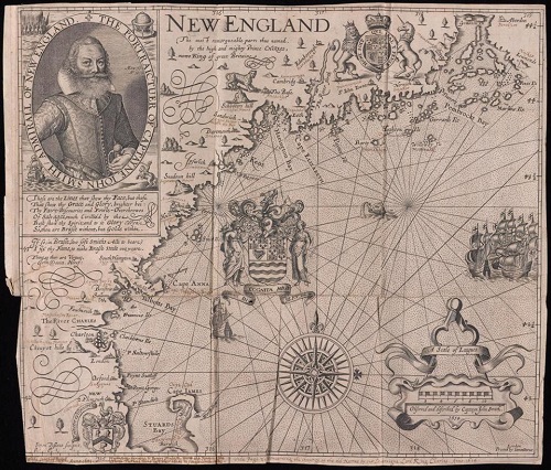
John Smith's version of New England in his 1616 map,The map is in the Beinecke Rare Book & Manuscript Library, at Yale University, in New Haven.
Michael Blanding has written a delightful piece for the June 15 Boston Globe about English explorer/entrepreneur John Smith's fantastical map of New England, published in 1616 and based on Mr. Smith's expedition of 1614. The map was the first document to call the region "New England''. Other English place names were plunked in on the order of the then crown prince of England, Charles (as in the Charles River).
You'd never know from the map that most of the region was woods and that the settlements were Indian, with, of course, Indian names. But then, Mr. Smith apparently really did think that a freer, happier version of Olde England could be planted in "New England,'' and rather rapidly.
I (Whitcomb) love the scorpion tail of "Cape James'' (named after the English king of the time, James I, Charles's father) now known as Cape Cod.
As Mr. Blanding noted: {T}he scale of Smith's fictitious landscape was an unprecedented act of virtual colonization, drawn before a single permanent English settlement had been founded'' in New England.
But by associating the region so closely with England with these names, he helped draw the English here to take over. They were lucky, if that is the word, that a series of epidemics of diseases introduced into the region by European traders and sailors, probably operating mostly along the Maine coast, about the time of the map wiped out the majority of the Indians, whose settlements had quite different names than the Plimouth, etc., that Mr. Smith gave them to drum up business. The Indians had no immunity from these Eurasian diseases, which included smallpox.
Thus southern New England has a mixture of Indian and English place names.