
Frank Carini: In two areas on R.I. coast — improvement and new challenges
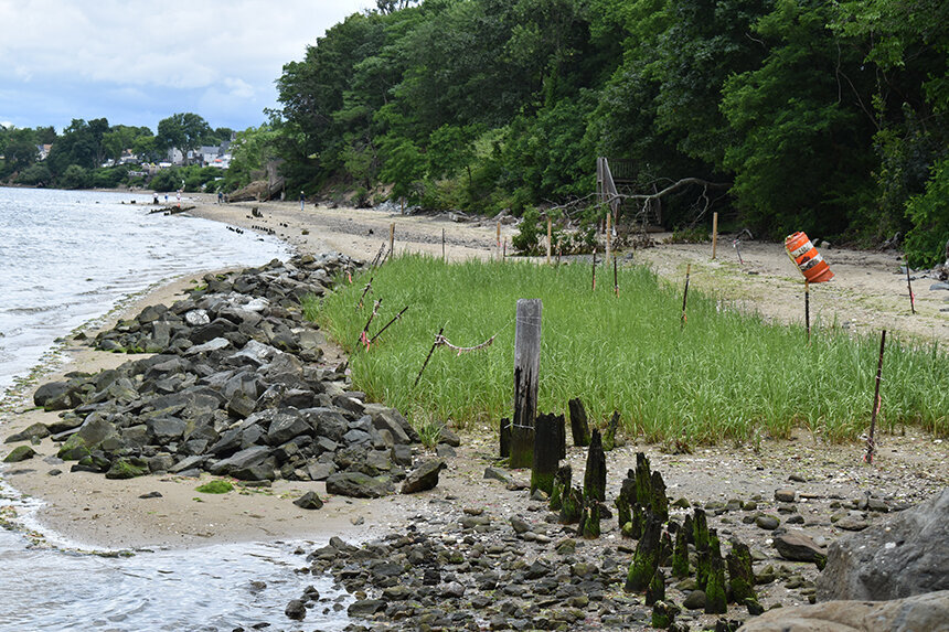
The Nature Conservancy and its partners installed a living shoreline at Rose Larisa Memorial Park, in East Providence, to help keep coastal erosion at bay.
— Photo by Frank Carini/ecoRI News)
From ecoRI News (ecori.org)
EAST PROVIDENCE, R.I.
Growing up in the 1970s and ’80s across the Seekonk and Providence rivers in Rhode Island’s capital, John Torgan spent plenty of time exploring the state’s urban shoreline.
He remembers them as dumps filled with sewage and littered with decaying oil tanks.
“They were horribly polluted,” said Torgan, who still lives in Providence. “No one was fishing or sailing.”
His childhood memories, however, also include the beauty of a peaceful island in the middle of a shallow 4-mile-long salt pond.
The fortunes of these waters and their surroundings have changed since an adolescent Torgan, now 51, was skipping rocks, collecting shells and investigating the coastline for marine life. The Providence and Seekonk rivers are still impaired waters, but, like the chain-link fence topped with barbed wire that once separated much of these waterways from the public, the derelict oil tanks have been removed. The rivers’ health has improved.
The two rivers, both of which share a legacy of industrial contamination and suffer from stormwater-runoff pollution, aren’t recommended for swimming, but life on, under and around them has returned. Menhaden, bluefish, river herring, eels, osprey and cormorants are now routinely spotted. The occasional seal, dolphin, bald eagle and trophy-sized striped bass visit. Kayakers, fishermen, scullers and birdwatchers are easy to find.
Torgan, who spent 18 years as Save The Bay’s baykeeper, called the comeback of upper Narragansett Bay “extraordinary” and “dramatic.” He credited the Narragansett Bay Commission’s ongoing combined sewer overflow project with making the recovery possible.
As for that summer cottage on Great Island in Point Judith Pond, he said “tremendous development” has changed the neighborhood. Bigger houses now surround the Torgan family’s saltbox cottage, adding stress to one of Rhode Island’s largest and most heavily used salt ponds.
There is a diverse mixture of development around the shores of the pond that straddles South Kingstown and Narragansett. In the urban center of Wakefield, at the head of the pond, and at the port of Galilee at its mouth, there is an abundance of commercial development and a corresponding amount of pavement. The impacts are beginning to show.
Early last year the Rhode Island Department of Environmental Management decided, based on ongoing water-quality monitoring results, to reclassify two areas of Point Judith Pond from approved to conditionally approved for shellfish harvesting. Water samples collected in the pond after certain rain events showed elevated bacteria levels and resulted in several emergency and precautionary shellfishing closures.
An underappreciated coastline
As an adult, Torgan’s interest in and passion about the marine environment hasn’t waned. The avid boater and angler has spent much of his working life protecting the Ocean State’s namesake, especially the waters not typically associated with its catchy moniker.
“This is the coast,” Torgan said while standing at the water’s edge at Rose Larisa Memorial Park. “The coast of Rhode Island doesn’t start at Rocky Point. It’s not just the beaches of South County.”
But, like most of the state’s coastline, the East Providence shoreline is vulnerable to accelerated erosion driven by the climate crisis and growing development pressures. Like much of the state’s urban shoreline, the health of this stretch of beach is better but hardly pristine. It is littered with chunks of asphalt and broken glass, most of its sharp edges dulled by tumbling in the sea. Swimming isn’t advised.
The climate challenges and improved health are why the organization Torgan currently heads, the Rhode Island chapter of The Nature Conservancy, took an interest in protecting this underappreciated stretch of beach.
More frequent and intense storms, combined with increasing sea-level rise, are eroding beaches and bluffs and damaging the state’s diminishing collection of coastal wetlands. Torgan said dealing with the negative impacts of this reality, plus increased flooding, is a huge challenge for Rhode Island’s 21 coastal communities. He noted adequately supported coastal resiliency projects that use nature are needed to inoculate the state against the changes that are coming.
To that end, The Nature Conservancy partnered with the Coastal Resources Management Council (CRMC) and the City of East Providence last year to test the effectiveness of “living shoreline” erosion controls at the popular Bullocks Point Avenue park.
The park’s steep coastal bluff rises 20-30 feet above a narrow beach. In several areas, however, erosion has crumbled sections of the bluff, exposed root balls and felled trees. Previous efforts to reduce erosion through human-made practices, such as the installation of riprap and seawalls, failed.
As its name suggests, the living shoreline model incorporated more natural infrastructure. Unlike concrete or stone seawalls, living shorelines are designed to prevent erosion while also providing wildlife habitat. Hardened shorelines, compared to living ones, also diminish public access.
The first step in returning nature to a prominent role at this coastal park, at the head of Narragansett Bay’s tidal waters, was removing debris, such as large concrete slabs more than 20 feet long that were sitting at the bottom of the bluff, left behind by those failed human attempts to keep Mother Nature at bay.
Then, at the northern end of the park, the bank was cut away to reduce the slope. Stone was placed at the base of the bluff and logs made of coconut fiber were installed farther up the slope. The bluff was planted with native coastal vegetation. Near the southern boundary, low piles of purposely placed rocks and rows of beachgrass and native plants were added.
In other areas along this stretch of upper Narragansett Bay beach, boulders, cement walls and wooden structures, to varying degrees of success, strain to keep East Providence backyards from eroding and the bay from encroaching.
“As a matter of policy, we need to change our relationship with water where we’re not trying to hold it back and keep it out,” Torgan said. “In a more comprehensive way, think about how can we manage it and create basins where we are welcoming the water. That will help with flooding. It will help with sea-level rise and storm damage. It will improve water quality. The long view is changing the mindset that says we need to wall off the rising water and instead think about natural approaches and strategies that allows us to move with it.”
He noted that while living shoreline techniques have been implemented elsewhere in the United States, few have been permitted, built and evaluated in New England. He said small-scale projects like this one give coastal engineers and coastal permitting agencies a better sense of their cost and effectiveness, most notably in areas that aren’t exposed to open-ocean shoreline, like along much of the South Coast, where these artificial marshes would likely be unable to blunt stronger wave action.
When the 2020 project was announced, CRMC board chair Jennifer Cervenka said, “Much of Rhode Island’s coastline is eroding, and it’s a problem with no easy fix. This nature-based erosion control is one of the first of its kind in Rhode Island, and New England. We can’t stop erosion completely, but living shoreline infrastructure like this might buy our shores some valuable time.”
The project, which cost about $230,000, was funded by a Coastal Resilience Fund grant from the National Oceanic and Atmospheric Administration, The Nature Conservancy, the Newport-based foundation 11th Hour Racing and the Rhode Island Coastal and Estuarine Habitat Restoration Trust Fund.
Frank Carini is editor of ecoRI News.
River view

A perfect day on Rhode Island’s mighty Seekonk River, at the upper end of Narragansett Bay
— Photo by Lydia Whitcomb

Frank Carini: The partial recovery of the Seekonk River

Looking out at the Henderson Bridge over the Seekonk from Providence’s Blackstone Park
From ecoRI News (ecori.org)
When driveways, highways, rooftops, patios and parking lots cover 10 percent of a watershed’s surface, bad things begin to happen. For one, stormwater-runoff pollution and flooding increase.
When impervious surface coverage surpasses 25 percent, water-quality impacts can be so severe that it may not be possible to restore water quality to preexisting conditions.
This where the Seekonk River’s resurgence runs into a proverbial dam. Impervious-surface coverage in the Seekonk River’s watershed is estimated at 56 percent. It’s tough to come back from that amount of development, but the the urban river is working on it, thanks to the efforts of its many friends.
The Seekonk River, from its natural falls at the Slater Mill Dam on Main Street in Pawtucket, R.I., flows about 5 miles south between the cities of Providence and East Providence before emptying into Providence Harbor at India Point. The river is the most northerly point of Narragansett Bay tidewater. It flows into the Providence River, which flows into Narragansett Bay.
While it continues to be a mainstay on the Rhode Island Department of Environmental Management’s list of impaired waters, the Seekonk River is coming back to life.
“I started rowing at the NBC [Narragansett Boat Club] 10 years ago when I realized that I was on the shores really of a 5-mile-long wonderful playground,” Providence resident Timmons Roberts said. “I just think it’s a magical place, and seeing the river come back to life has meant a lot to me.”
The Narragansett Boat Club, which has been situated along the Seekonk River since 1838, recently held an online public discussion about the river’s recovery.
Jamie Reavis, the organization’s volunteer president, noted the efforts that have been made by the Blackstone Parks Conservancy, Fox Point Neighborhood Association, Friends of India Point Park, Institute at Brown for Environment and Society, Providence Stormwater Innovation Center, Save The Bay, and Seekonk Riverbank Revitalization Alliance, among others, to restore the beleaguered river.
“Having rowed on the river for over 30 years now, I can attest to their efforts,” Reavis said. “It was practically a dead river. It almost glowed in the dark back in the day. It is now teaming with life. Earlier this summer, a bald eagle flew less than 10 feet off the stern of my single with a fish in its talons. Watching it fly across the river and up into the trees is a sight I will not soon forget, nor is it one I could have imagined witnessing 30 years ago.”
Decades of pollution had left the Seekonk River a watery wasteland.
In the late 18th and early 19th centuries some of the first textile mills in Rhode Island were built along the Seekonk River. The river, and one of its tributaries, the Blackstone River, powered much of the early Industrial Revolution. Mills that produced jewelry and silverware and processes that included metal smelting and the incineration of effluent and fuel left the Seekonk and Blackstone rivers polluted.
There are no longer heavy metals present in the water column of the Seekonk River, but sediment in the river contains heavy metals, including mercury and lead.
Swimming in the Seekonk River, which doesn’t have any licensed beaches, and eating fish caught in it aren’t recommended because of this toxic legacy and because of the continued, although declining, presence of pathogens, such as fecal coliform and enterococci. The state advises those who recreate on the river to wash after they have been in contact with the water. It also advises people not to ingest the water.
But, as both Roberts and Reavis noted, the Seekonk River is again rich with life and activity. River herring, eels, osprey, cormorants, gulls and the occasional seal and bald eagle can be found in and around the river. The same can be said of kayakers, fishermen, scullers, and birdwatchers.
The river’s ongoing recovery, however, is threatened by rising temperatures, sewage nutrients and runoff from roads, lawns, parking lots, and golf courses in two states that dump gasoline, grease, oil, fertilizer, and pesticides into the long-abused waterway.
The Sept. 30 discussion was led by Sue Kiernan, deputy administrator in the Rhode Island Department of Environmental Management’s Office of Water Resources. She has spent nearly four decades, first with Save The Bay and the past 33 years with DEM, working to protect upper Narragansett Bay.
She spoke about how water quality in upper Narragansett Bay, including the Seekonk River, has improved through efforts both large and small, from the Narragansett Bay Commission’s ongoing combined sewer overflow (CSO) abatement project to wastewater treatment plants reducing the amount of contaminants being dumped into the waters of the upper bay to brownfield remediation projects to the many volunteer efforts, such as the installation of rain gardens and the planting of trees, conducted by the organizations that sponsored her presentation.
She noted that nitrogen loads, primarily from fertilizers spread on lawns and golf courses, that are washed into the river when it rains, lead to hypoxia — low-oxygen conditions — and fish kills. Since 2018, six reported fish kills that combined killed thousands of Atlantic menhaden have been documented by DEM’s Division of Marine Fisheries in the Seekonk River.
Kiernan said excessive nutrients, such as nitrogen, stimulate the growth of algae, which starts a chain of events detrimental to a healthy water body. Algae prevent the penetration of sunlight, so seagrasses and animals dependent upon this vegetation leave the area or die. And as algae decay, it robs the water of oxygen, and fish and shellfish die, replaced by species, often invasive, that tolerate pollution.
While these nutrient-charged events remain a problem, she said, the overall habitat of the Seekonk River is improving. Kiernan noted that in recent years some 20 species of fish, including bluefish, black sea bass, striped bass, scup, and tautog, have been documented in the river.
The Seekonk River is still a stressed system, but Kiernan said the river is seeing a positive trend in its recovery.
“We’re not in a position to suggest that its been fully restored, and honestly I don’t think that we’ll be in a position to do that until we get the CSO abatement program further implemented,” she said. “But I think you can take some satisfaction in knowing that there are days where things look OK out there.”
Frank Carini is editor of ecoRI News.
Try trains again

Providence’s infamous stuck-up bridge over the Seekonk River
From Robert Whitcomb’s “Digital Diary’’ in GoLocal245.com
Architectural historian and critic William Morgan’s recent entertaining GoLocal column with zany ideas (ski jump!) on what to do with the abandoned railroad bridge over the Seekonk River at the head of Narragansett Bay served to remind many of us that a light-rail line from Providence down through East Providence, Barrington, Warren and Bristol would make a lot of sense. And maybe it could eventually be extended across to Aquidneck Island via a railroad bridge next to the Mount Hope Bridge.
After all, it’s a densely populated strip with distinct town centers (for stations). It would make a lot of environmental and economic sense to lay down the line even if that meant putting it where the East Bay Bike Path (formerly a rail route!) is now. You can move a lot more people by train than by bike, and do it in all weather.
In any event, we need to better knit together the improving post-industrial waterfront of East Providence with Providence’s eastern shore.
To read Mr. Morgan’s column, please hit this link.
Maybe Mr. Morgan could do another essay on Providence’s “Superman Building,’’ this one with some fantastical suggestions – e.g., hanging gardens, a recirculating waterfall, an aviary at the top….
Hit this link to read his last column on that Art Deco skyscraper.