
Grace Kelly: Reef balls deposited to lure sport fish
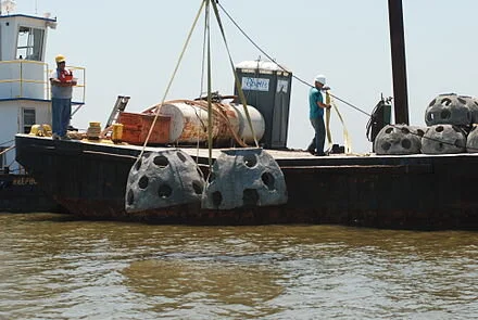
Reef balls being dropped into an area to lure fish in the Gulf of Mexico
From ecoRI News (ecori.org)
EAST PROVIDENCE, R.I.
The mayor, a slew of media members, and a group of residents celebrating a birthday — complete with cake and party hats — gathered Oct. 24 at Sabin Point here, at the head of Narragansett Bay, to watch not one, but 64 balls, drop.
But unlike the ball drop to kick off the New Year, these balls are more like dome-shaped mounds, flat on the bottom, made of concrete and silica and hollow, three feet high and four feet wide, and with large holes gouging their surfaces. Their purpose: bring sport fish to Sabin Point.
These balls will create an artificial reef, the first of its kind in Rhode Island, as a result of a partnership between The Nature Conservancy and the Rhode Island Department of Environmental Management (DEM).
“Part of this work began four years ago when DEM and The Nature Conservancy partnered up to start monitoring the upper bay, and through this we decided this location would be good for fish enhancement since it has access to fish by shore, not just by boat,” said Patrick Barrett, a DEM fisheries specialist. “The money used for this was raised and provided by taxes on fishing gear, so we’re trying to give back to the community.”
Specialty Diving transported the 64 reef balls via barge from Quonset Point to Sabin Point.
Many sport fish, specifically tautog, scup, and sea bass, like structured spaces, and, according to Tim Mooney of The Nature Conservancy, the reefs will allow minnows the security to grow into adulthood.
“The reefs should attract these fish and we’re hoping that it will increase their survival rate,” he said.
As part of the installation, DEM and The Nature Conservancy will monitor the progress in this location against other areas in the bay.
“We will be monitoring this area once a month, and every fall we’ll probably dive the reef as well,” Barrett said. “We’re interested to see what happens.”
Grace Kelly is an ecoRI News journalist.
Editor’s note: Supports for offshore wind turbines also attract fish.
'Coastal strongholds' against rising seas

Salt marsh along Long Island Sound in Connecticut.
From ecoRI News (ecori.org)
A new study conducted by The Nature Conservancy helps identify “coastal strongholds” — areas that because of their unique topographies, elevations and landforms give threatened habitats in Rhode Island a chance to escape rising sea levels and continue to provide vital services to people and wildlife.
The 280-page study also offers land managers and agencies a tool to gather comprehensive data, such as water quality, important wildlife areas, sediment and soil nitrogen levels, that can be used to develop targeted conservation plans that will have the greatest chance of protecting coasts and communities against sea-level rise.
Among the strongholds identified in the Ocean State are Prudence Island and the salt marshes along the Palmer River between Barrington and Warren based on the undeveloped lands that surround them. The report notes that even these areas are threatened.
With sea levels projected to rise as much as six feet by the next century, many coastal habitats — tidal marshes, sandy beaches, and seagrass beds — could disappear under rising waters.
But scientists say these “strongholds” provide escape routes that allow threatened habitats to migrate inland and survive sea-level rise. The authors of the study, however, warn that manmade development and pollution could cut off these escape routes and lead to habitats being drowned out of existence.
“This study illustrates the vulnerability of coastal wetlands and the need to conserve and restore them,” said John Torgan, state director of The Nature Conservancy in Rhode Island. “It also demonstrates the need to continue to implement nature-based solutions at all Rhode Island marshes that are highly vulnerable to sea-level rise because they don’t have room to migrate inland.”
During the past 18 months, the Conservancy and the U.S. Fish & Wildlife Service have raised the elevation of 40 acres of marsh at the John H. Chafee and Sachuest Point National Wildlife refuges. In July, the Conservancy received a $1 million Coastal Resilience grant from the National Oceanic and Atmospheric Administration to increase the use of nature-based infrastructure for flood protection in New England. The Conservancy plans to hire a regional coastal-resilience specialist and implement a large-scale restoration project in each of the five coastal New England states.
The coastal strongholds research is supported by federal funding for Hurricane Sandy recovery, in response to a need identified by a coalition of states, federal agencies and other conservation organizations for information to help land managers and communities make strategic decisions to help coastal systems and communities adapt to changing conditions.
Healthy coastal habitats, such as sand dunes and tidal marshes, can shield communities from storm surges while also providing feeding and nursing grounds for wildlife. Sandy beaches serve as breeding grounds for rare species while supporting local tourism economies. Salt marshes rival forests in carbon storage and provide habitat for one of the East Coast’s rarest birds: the saltmarsh sparrow.
The Atlantic Coast Joint Venture — a partnership of federal, regional, state and local agencies and organizations — is already planning to use the tool to identify priority habitat for the saltmarsh sparrow and two other species, black rail and American black duck, that depend on salt-marsh habitat by looking for parcels in migration corridors that may be eligible for funding through Natural Resources Conservation Service programs to support conservation on working lands.
“If these important habitats disappear, it will have severe impacts on our economy, our environment and the health of our communities,” Torgan said. “Sea-level rise is happening now. We must take conservation action now to ensure these coastal habitats that provide so many services to both people and nature don’t disappear forever.”
The study analyzed landforms, elevations, nitrogen and sediment inputs, manmade development and other characteristics of 11,000 coastal sites from Maine to Virginia. Areas with open spaces, low-lying landscapes, good freshwater flow, low nitrogen, and diverse shorelines with many inlets provided habitats the greatest chance to migrate and take root inland. Conversely, areas with steep cliffs or high elevations will block migration, and too much nitrogen can disrupt root development. Manmade structures such as seawalls or buildings can also cut off escape routes.
The study was funded by the U.S. Fish & Wildlife Service.

The Palmer River (oil), by Edward Mitchell Bannister (1828-1901).
3-year floodplain-restoration project to start soon along the Connecticut River in Mass.

"View of Springfield {just south of Springfield}, on the Connecticut River,'' by Alvan Fisher.
Via ecoRI News (ecori.org)
LONGMEADOW, Mass.
Large-scale restoration of natural floodplain features and native plants will begin soon on land along the Connecticut River, including 223 acres recently transferred to The Nature Conservancy (TNC) by the trustees of the former Fannie Stebbins Memorial Wildlife Refuge.
Easily visible from Interstate 91 in the suburbs of Springfield, the land is part of one of the most sizeable natural and largely protected floodplain areas in the Connecticut River watershed. In addition to the land-based restoration efforts, work also will take place on part of the adjoining Silvio O. Conte National Fish & Wildlife Refuge and town of Longmeadow lands.
Floodplains are natural water‐storage areas for snowmelt, spring rains and, increasingly, severe storms that cause the Connecticut River and its tributaries to overflow. These areas also act as natural filters, trapping sediment, nutrients and pollutants before they reach rivers and coastal seas, thereby improving water quality.
“Floodplains once covered wide stretches along the Connecticut River and its tributaries, but today, they’re only a fraction of this important ecosystem,” said Kim Lutz, director of TNC’s Connecticut River Program. “The Fannie Stebbins land presents a remarkable opportunity to protect and restore a portion of that habitat.”
TNC and U.S. Fish & Wildlife Service are leading the three-year restoration project, which will include reduction of forest fragmentation by returning seven old fields to floodplain forest; control of invasive plants; and restoration of natural hydrological features.
Work on the 223-acre TNC section is being completed with funding from the Agricultural Conservation Easement Program administered by the U.S. Department of Agriculture’s Natural Resources Conservation Service (NRCS).
This spring, the NRCS purchased a permanent wetlands reserve easement on this section — the first such easement in Massachusetts on the mainstem of the Connecticut River.
“The benefits of restoring, enhancing and protecting critical wetlands cannot be overstated,” said Christine Clarke, Massachusetts State Conservationist for NRCS.
After the easement purchase, fee ownership of the land, plus another 21 acres, was donated to TNC.
This land was previously part of the Fannie Stebbins Memorial Wildlife Refuge owned and managed by a board of trustees elected by the Allen Bird Club, whose members had the foresight to acquire the land in multiple, separate parcels beginning more than 60 years ago.
The refuge was named for Fannie Stebbins, a nationally recognized biologist and educator who was head of Science and Nature Studies in the Springfield School System in the 1930s and ’40s. In 1972, the National Park Service designated the Stebbins Refuge a National Environmental Education Landmark. Massachusetts Audubon has recognized it as an “Important Bird Area,” as hospitable lodging for migrating birds.
In keeping with the Stebbins trustees’ wishes, the land is planned to eventually become part of the Conte Refuge, after the three-year restoration project.
During the three-year restoration project, activities will include mowing, herbiciding and plowing the fields to prepare for tree planting; targeted use of herbicide in forested areas to control invasive plants; and the use of heavy equipment to remove a berm. Temporary closures over portions of the area will occur for public safety when work is underway.