
Vox clamantis in deserto


‘Alvin’ goes the deepest yet
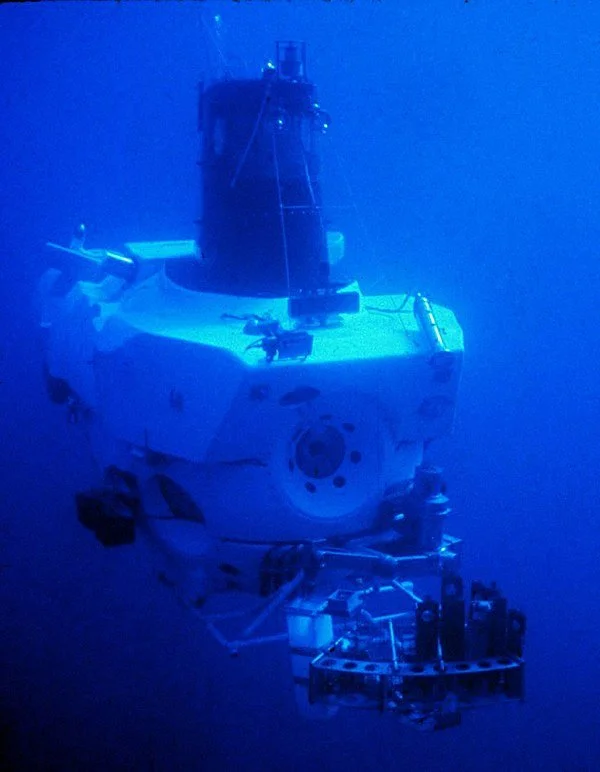
Alvin at work
An edited version of a New England Council (newenglandcouncil.com) report:
“The Woods Hole Oceanographic Institution’s (a New England Council member) human-guided submersible ‘Alvin’ research vessel has made history by reaching a depth of 6,453 meters (about 21,117 feet). The three-person crew guided the submersible in the Puerto Rico Trench, off that island .… Alvin’s success has led to 99 percent of the seafloor being available for the submersible to explore.
“The submersible is well-known around the world for being an icon of excellent scientific data collecting and engineering. ‘Alvin’ is one of the only U.S. submersibles that have the equipment to carry humans and gather scientific data from extreme depths. Since its initial launch, ‘Alvin’ has carried out 5,086 successful dives. Its long history goes back to when Woods Hole scientist Robert Ballard used ‘Alvin’ to explore the wreckage of the HM Titanic. This summer ‘Alvin’ went through an intense series of sea trials overseen by the NAVSEA, an organization responsible for building U.S. Navy ships. The trials permitted ‘Alvin’ to dive to its maximum depth. The next step for ‘Alvin’ will be a two-week National Science Foundation-funded verification expedition to determine if ‘Alvin’ can maintain its ability to support deep-sea scientific research.
“Woods Hole President Peter de Menocal said, “[i]nvestments in unique tools like ‘Alvin’ accelerate scientific discovery at the frontier of knowledge. Alvin’s new ability to dive deeper than ever before will help us learn even more about the planet and bring us a greater appreciation for what the ocean does for all of us every day.”’
Read more from the Woods Hole Oceanographic Institution.
Woods Hole (part of Falmouth), with Woods Hole Oceanographic Institution and Marine Biological Laboratory buildings
WHOI gets grant to study ocean's microbial food web

View of Woods Hole Oceanographic Institution and Marine Biological Laboratory buildings in the Woods Hole village of Falmouth, on Cape Cod
From The New England Council (newenglandcouncil.com)
Researchers at the Woods Hole Oceanographic Institute (WHOI) recently received funding to study vital processes that help maintain the health of the ocean and the planet. Scientists Dan Repeta and Benjamin Van Mooy received two grants totaling $2.7 million from the Simons Foundation.
Repeta’s research will focus on phosphorus, iron and nitrogen, the nutrients that fuel microbial cycles in the ocean. Van Mooy’s research will focus on understanding the carbon and energy flow through the microbial food web. Both projects will use samples and data collected from Station ALOHA, a six-mile circle north of Hawaii, an important hub for oceanographic study. The Simons Foundation funding will also support further research into the mesopelagic zone, which plays a major role in sequestering the oceans carbon.
“We are grateful for the generous support of the Simons Foundation for basic research that is the fundamental underpinning of our knowledge of the ocean,’’ said Richard Murray, WHOI deputy director and vice president for Research. “Understanding elemental ocean processes is the equivalent of understanding the human body’s basic workings. Without this information, we cannot understand, or protect, our ocean’s and planet’s health.”
The New England Council commends the WHOI for its advances in the world of oceanographic studies and congratulates Dan Repeta and Benjamin Van Mooy on this award. Read more at News from WHOI.
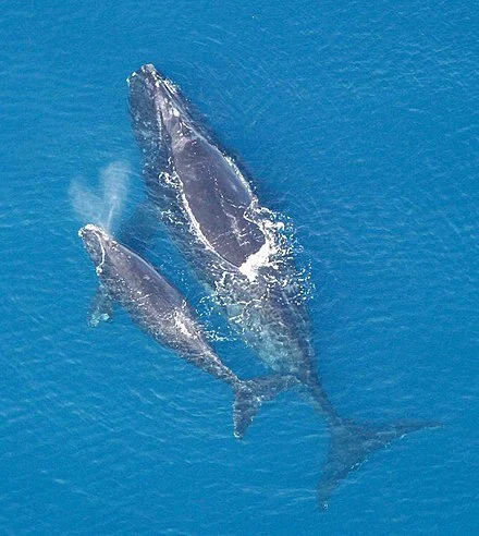
Study is aimed at protecting right whales in offshore windpower areas

North Atlantic right whale mother with calf
From ecoRI News (ecori.org)
Ørsted is funding a project to study and protect endangered North Atlantic right whale during surveys, construction and operation of its U.S. offshore wind facilities such as Bay State Wind and Revolution Wind.
Using data collected from an aerial, unmanned glider and two sound-detection buoys, researchers from the University of Rhode Island, Rutgers University and the Woods Hole Oceanographic Institution will examine the habitat and behaviors of right whales in the wind-lease areas awarded to Ørsted.
An estimated 400 North Atlantic right whales remain, fewer than 100 are breeding females.
The oceanographic data will help studies of additional fish species and improve forecasting for severe storms and other weather, according to Ørsted. The three-year initiative is called Ecosystem and Passive Acoustic Monitoring (ECO-PAM).
Vineyard Wind watch
A key offshore wind report is expected this week from the Coast Guard. The draft of the Massachusetts and Rhode Island Port Access Route Study (MARIPARS) will recommend wind farm layouts, spacing, and transit lanes for vessel safety, navigation, and search-and-rescue operations.
The draft report will be followed by a 45-day comment period. The Coast Guard is expected to finalize the report in April.
At its nearest point, the Vineyard Wind project is about 14 miles from the southeast corner of Martha’s Vineyard and a similar distance from the southwest side of Nantucket. (BOEM)
At its nearest point, the Vineyard Wind project is about 14 miles from the southeast corner of Martha’s Vineyard and a similar distance from the southwest side of Nantucket. (BOEM)
The recommended wind-facility grid is expected to inform the forthcoming draft environmental impact statement (EIS) from the Bureau of Ocean Energy Management (BOEM) for the Vineyard Wind project. If adopted by BOEM, MARIPARS will accelerate other wind proposals in the federal lease areas off southern New England.
BOEM won’t give any hints about when it will release the expanded EIS for the Vineyard Wind project. BOEM media representatives will only say to look for updates at its Vineyard Wind Web site.
The expanded EIS will focus on fishing and other impacts of offshore wind development in the region. The initial EIS was expected by the end of last year but pushed until early 2020.
The initial EIS was delayed last summer after the National Marine Fisheries Service and the National Oceanic and Atmospheric Administration declined to endorse the report.
After hearings and a public comment period on the upcoming EIS, a record of decision from BOEM on the Vineyard Wind project isn’t likely until December. If approved, major work on the 800-megawatt wind facility, such as pile driving, can’ commence until May 1, 2021. An agreement to protect North Atlantic right whales with three environmental groups signed last year prohibits such work between January and April.
Foster wind moratorium
The Foster (R.I.) Town Council recently approved a 180-day moratorium on wind-turbine development. There are no proposals before the town, but the council wants to give the Planning Board time to write an ordinance for future wind development.
“There’s speculation whether companies would be interested in coming into our town and we want to make sure we had things in order,” Town Council president Denise DiFranco said at the council’s Jan. 23 meeting.
The council can extend or shorten the moratorium. Residential wind systems less than 100 kilowatts are still permitted.
Virginia wind
Virginia is upping its involvement in offshore wind with a vision to reach World War II levels of maritime industrial activity. Last September, Dominion Energy, the owner of natural-gas pipelines and power plants, including the Manchester Street Power Station, in Providence, announced plans for a 2,600-megawatt wind facility off Virginia Beach. Gov. Ralph Northam has since set a state energy target of 30 percent renewable power by 2030 and 100 percent by 2050.
Dominion is also developing a two-turbine offshore test site called the Coastal Virginia Offshore Wind Project with Ørsted. The project could be operational by late this year.
Like many states in the Mid-Atlantic and Northeast, Virginia wants to expand its ports to build maritime centers for wind turbine construction, maintenance, and shipping. An estimated 14,000 jobs could be created by the new maritime industries in the state.
Tim Faulkner is an ecoRI News journalist.
Move the FDA to Boston?
]

Harvard Medical School quadrangle in Longwood Medical Area, Boston.
Adapted from Robert Whitcomb’s “Digital Diary,’’ in GoLocal24.com:
One of the most intriguing of the ideas in \Philip K. Howard’s new book – Try Common Sense: Replacing Failed Ideologies of the Left and Right -- is to move a lot of federal operations out of Washington to get them away from the entrenched lobbyist-run corruption there and closer to the people and in some cases to outstanding local expertise. Such moves would liberate more federal employees to take decisions in the public interest.
The crux of Mr. Howard’s books is that people should exercise more individual judgment and take on more responsibility instead of turning over so much of their lives to regulations and legalism. They should be encouraged to exercise common sense.
“All the ligaments and tendons of Washington’s permanent apparatus – civil servants, lobbyists, lawyers, contractors, media and politicians – are conditioned to play their roles in its giant bureaucratic apparatus.’’ (I happen to think that the civil servants are the best of the lot….)
So Mr. Howard writes: “How can we govern sensibly or morally when officials in Washington refuse to change direction? The answer is that we can’t. …Why fight this culture head on? Start moving agencies out of Washington to places where people are not afraid of taking responsibility.’’ Big companies move all the time. Why not agencies? And some could be moved to places with considerably lower operating costs than metro Washington.
Mr. Howard suggests, for example, that the Food and Drug Administration’s headquarters could be moved to Boston or California, where there are many, many physicians, biologists and others in health-care-related fields. Or the Department of Housing and Urban Development could go to Detroit. Consider that the Centers for Disease Control and Prevention works well with its Atlanta headquarters.
This redistribution would also more fairly share the vast wealth associated with the federal government, which is so heavily concentrated in the Washington, D.C., region, which vies with San Francisco as the richest metro area in America.
Whether or not you agree with Mr. Howard on this or that policy proposal, you have to give him credit for, as he told me, “trying to change how people think about’’ government and civil society/citizenship in general. That has to be the start.
Oh yes, let’s move all or part of the National Oceanic and Atmospheric Administration to the great ocean research center of Woods Hole.

A view of downtown Woods Hole from the water, including Marine Biological Laboratory and the Woods Hole Oceanographic Institution.

Woods Hole Oceanographic to study ecosystem south of Martha's Vineyard
-- Photo by Ben Frantz Dale
View of the Woods Hole section of Falmouth, Mass., showing Woods Hole Oceanographic Institution and Marine Biological Laboratory buildings.
This from the New England Council:
"The Woods Hole Oceanographic Institution, a New England Council member, recently announced that scientists from the institution will lead a long-term research project to study the ecosystem of the Northeast Shelf of the Atlantic Ocean.
"The study will focus on studying plankton in the waters south of Martha’s Vineyard in order to record how environmental changes are affecting the plankton population, which serves as the backbone for the entire ecosystem. By identifying changes year to year, the scientists can determine how the aquatic food chain may be changing over time and how healthy the ecosystem is. To collect data, the scientists will use two ocean observatory sites, deploy 'sophisticated sensors,' and carry out field research via boat trips to the area. The National Science Foundation awarded $6 million for five years of the study, with the possibility of extending funding when the research team present their results to the National Science Foundation at the end of the five years.
"Heidi Sosik, project leader and senior scientist at the Institute, explained that the study results could hold meaning for the region’s fishing industry because the health of the region’s plankton population can impact fishery production. 'The environment is changing. I know it, and the fishermen know it,' explained Sosik. 'But by keeping the lines of communication open, we can preserve the environment while still not disrupting business.'
"The New England Council congratulates Woods Hole Oceanographic Institution on the grant for this latest study focusing on the health of New England’s aquatic ecosystem. Read more in The Boston Globe and Cape Cod Times
Those great New England hurricanes of deep history
WOODS HOLE, Mass.
Intense hurricanes, possibly more powerful than any storms New England has experienced in recorded history, frequently pounded the region during the first millennium, from the peak of the Roman Empire into the height of the Middle Ages, according to a new study by the Woods Hole Oceanographic Institution (#whoi).
The findings could have implications for the intensity and frequency of hurricanes the United States could experience as ocean temperatures increase as a result of climate change, say study’s authors.
A new record of sediment deposits from Cape Cod show evidence that 23 severe hurricanes hit New England between the years 250 and 1150, the equivalent of a severe storm about once every 40 years. Many of these hurricanes were likely more intense than any that have hit the area in recorded history, according to the study. The prehistoric hurricanes were likely category 3 storms (Hurricane Katrina ) or category 4 storms (Hurricane Hugo) that would be catastrophic if they hit the region today, according to Jeff Donnelly, a WHOI scientist and the study’s lead author.
The study is the first to find evidence of historically unprecedented hurricane activity along the northern East Coast, Donnelly said. It also extends the hurricane record for the region by hundreds of years, back to the first century, he said.
“These records suggest that the pre-historical interval was unlike what we’ve seen in the last few hundred years,” Donnelly said.
The most powerful storm to hit Cape Cod in recent history was Hurricane Bob in 1991, a category 2 storm that was one of the costliest in New England history. Storms of that intensity have only reached the region three times since the 1600s, according to Donnelly.
The intense prehistoric hurricanes documented by the study were fueled in part by warmer sea surface temperatures in the Atlantic Ocean during the ancient period investigated in the study than have been the norm off the East Coast during the past few hundred years. However, as oceans temperatures have slowly inched upward in recent decades, the tropical North Atlantic sea surface has surpassed the warmth of prehistoric levels and is expected to warm further over the next century as the climate heats up, Donnelly said.
He said the new study could help scientists better predict the frequency and intensity of hurricanes that could hit the U.S. coast in the future.
“We hope this study broadens our sense of what is possible and what we should expect in a warmer climate,” Donnelly said. “We may need to begin planning for a category 3 hurricane landfall every decade or so rather than every 100 or 200 years. The risk may be much greater than we anticipated.”
Donnelly and his colleagues examined sediment deposits from Salt Pond in Falmouth. The pond is separated from the ocean by a 4.3- to 5.9-foot-high sand barrier. Over hundreds of years, strong hurricanes have deposited sediment over the barrier and into the pond, where it has remained undisturbed.
The researchers extracted 30-foot-deep sediment cores that they then analyzed in a laboratory. Similar to reading a tree ring to tell the age of a tree and the climate conditions that existed in a given year, scientists can read the sediment cores to tell when intense hurricanes occurred.
The study’s authors found evidence of 32 prehistoric hurricanes, along with the remains of three documented storms that occurred in 1991, 1675 and 1635.
The prehistoric sediments showed that there were two periods of elevated intense hurricane activity on Cape Cod — from 150 to 1150 and 1400 to 1675. The earlier period of powerful hurricane activity matched previous studies that found evidence of high hurricane activity during the same period in more southerly areas of the western North Atlantic Ocean basin, from the Caribbean to the Gulf Coast. The study suggests that many powerful storms spawned in the tropical Atlantic between 250 and 1150 also battered the East Coast.
The deposits revealed that these early storms were more frequent, and in some cases were likely more intense, than the most severe hurricanes Cape Cod has seen in historical times, including Hurricane Bob and a 1635 hurricane that generated a 20-foot storm surge, according to Donnelly.
High hurricane activity continued in the Caribbean and Gulf of Mexico until 1400, although there was a lull in hurricane activity during this time in New England, according to the study. A shift in hurricane activity in the North Atlantic occurred around 1400, when activity picked up from the Bahamas to New England until about 1675.
The periods of intense hurricanes uncovered by the new research were driven in part by intervals of warm sea surface temperatures that previous research has shown occurred during these time perio