

The wet look

Sunny day flooding in Miami during a “king tide’’.
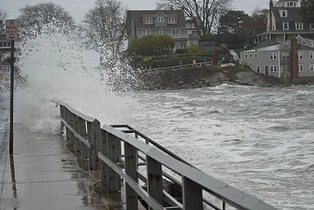
Coastal flooding in Marblehead, Mass., during Superstorm Sandy on Oct. 2012.
Adapted from Robert Whitcomb’s “Digital Diary,’’ in GoLocal24.com
The stuff below is a heavily edited version of some of the remarks I made in a talk a couple of weeks ago and seem to me particularly resonant as we head into summer coastal vacation season:
Most of us are in denial or oblivious when it comes to sea-level rise caused by global warming. For example, Freddie Mac researchers have found that properties directly exposed to projected sea-level rise have generally gotten no price discount compared to those that aren’t, though that may be changing. And some states don’t require sellers to disclose past coastal floods affecting properties for sale. Politicians often try to block flood-plain designations because they naturally fear that they would depress real-estate values.
So the coast keeps getting more built up, including places that may be underwater in a few decades. It often seems that everyone wants to live along the water.
As the near-certainty of major sea-level rise becomes more integrated into the pricing calculations of the real-estate sector, some people of a certain age can get bargains on property as long as they realize that the property they want to buy might be uninhabitable in 20 years. Younger people, however, should seek higher ground if they want to live near the ocean for a long time.
A tricky thing is that real estate can’t just be abandoned—it must pass from one owner to another. Some local governments’ coastal permits require owners to pay to remove their structures when the average sea level rises to a certain point. Absent such requirements, many local governments’ budgets may not be enough to pay for demolition or the moving costs associated with inundation. There are some interesting liability issues here.
What to do?
Administrative mitigation would include raising federal flood-insurance rates and more frequently updating flood-projection maps. More localities can take stronger steps to ban or sharply limit new structures in flood-prone areas and/or order them removed from those areas. And, as implied above, they should implement flood-experience-and-projection disclosure requirements in sales documents.
As for physical answers to thwarting the worst effects of sea-level rise, especially in urban areas, many experts believe that some form of the Dutch polder approach, which integrates hard stone, concrete or even metal infrastructure, and soft nature-based infrastructure, along with dikes, drainage canals and pumps, may have to be applied in some low places, such as Miami and Boston’s Seaport District. Barrington and Warren, R.I., look like polder country.
Polders are large land-and-water areas, with thick water-absorbent vegetation, surrounded by dikes, where the ground elevation is below mean sea level and engineers control the water table within the polder.
Just hardening the immediate shoreline, and especially beaches, with such structures as stone embankments to try to keep out the water won’t work well. That just makes the water push the sand elsewhere and can dramatically increase shoreline erosion.
On the other hand, creating so-called horizontal levees – with a marshy or other soft buffering area backed with a hard surface -- can be a reasonable approach to reduce the impact of storms’ flooding on top of sea-level rise.
Certainly establishing marshes (and mangrove swamps in tropical and semi-tropical coastal communities) can reduce tidal flooding and the damage from storm waves, but that may be a political nonstarter in some fancy coastal summer- or winter-resort places. Then there’s putting more houses and even stores and other nonresidential buildings on stilts, though that often means keeping buildings where safety considerations would suggest that there shouldn’t be any structures, such as on many barrier beaches. Still, it would be amusing to see entire large towns on stilts. Good water views.
Oyster and other shellfish beds can be developed as (partly edible!) breakwaters. And laying down permeable road and parking lot pavements can help sop up the water that pours onto the land. I got interested in how shellfish beds can act as a brake on flood damage while editing a book about Maine aquaculture last year. Of course, the hilly coast of Maine provides many more opportunities to enjoy a water view even with sea-level rise while staying dry than does, say, South County’s barrier beaches.
In more and more places where sea-level rise has caused increasing ‘’sunny day flooding’’ -- i.e., without storms -- streets are being raised.
I’m afraid that, barring, say, a volcanic eruption that rapidly cools the earth, slowing the sea-level rise, the fact is that we’ll have to simply abandon much of our thickly developed immediate coastline and move our structures to higher ground.
Working-waterfront enterprises -- e.g., fishing and shipping -- must stay as close to the water as possible. But many houses, condos, hotels, resorts and so on can and should be moved in the next few years. If they don’t have to be on a low-lying shoreline, they shouldn’t be there as sea level rises. For that matter, entire large communities may have to be entirely abandoned to the sea even in the lifetime of some people here.
Coastal communities and property owners face hard choices: whether to try to hold back the rising ocean or to move to higher ground. Nothing can prevent this situation from being expensive and disruptive.
Common sense would suggest that we not build where it floods and that we should stop recycling flooded properties. Again, flood risks should be fully disclosed and we need to protect or restore ecologies, such as marshes, shellfish and coral reefs and dune grass, that reduce flooding and coastal erosion.
Nature wins in the end.
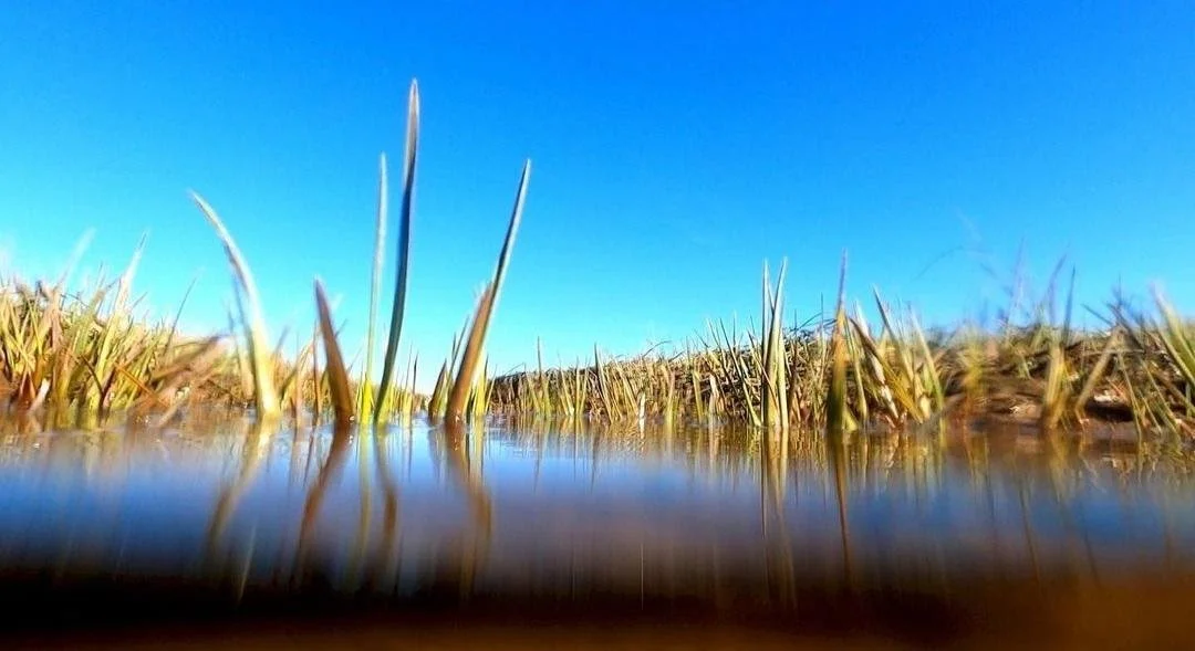
Treasure trove of life.
“Messages From the Marsh” (video still), by Amy Kaczur, in her show at Kingston Gallery, Boston, through Feb. 26.
Her Web site says:
“Kaczur’s work is grounded in environmental concerns, community and language. Her latest projects are fueled by a sense of urgency related to water issues, specifically coastal flood zones and rising sea levels. She grew up outside Cleveland, with family ties working in farming, food industry, mills, and coal mines in rural southern Ohio to the edges of Appalachia. Those roots impacted her experience of landscape and environmental issues such as pollution and climate change, and the multilayered struggles between land use and conservation. Along with examining these issues in her art practice, she works at Massachusetts Institute of Technology as the group administrator for two research labs focused on air and water pollution, climate change, and clean energy development and storage. She continuously develops her art practice, supported by relentless research, discovery by experiment, and the pleasure of inquisitive searching.’’
Trying to fine tune a salt marsh

From Robert Whitcomb’s “Digital Diary,’’ in GoLocal24.com
WBUR, one of the two major NPR stations in Boston (the other is WGBH), ran a nice story July 2 about efforts to improve New England’s largest salt marsh, in Massachusetts’s northeast corner, in the Parker River National Wildlife Refuge. Over the years, farmers, to encourage the growing of salt-marsh hay for livestock, and other local residents seeking to control the mosquito population, had ditches dug to drain what was seen as excess water from the marsh. But, says WBUR reporter Miriam Wasser, that did some damage to some creatures and the marsh’s general health and so some of its drainage ditches were blocked.
But wait! Maybe they went overboard. So, as wildlife biologist Nancy Pau told Ms. Wasser:
"Our concern about too much draining has shifted, and the concern now is that the marsh is getting too much flooding," she says. “It’s important for the marsh to get flooded, but also for the water to come back off. Anything that interrupts either of those two processes can negatively impact the marsh," which is a buffer against sea-level rise. Among the negative effects of bad water flow are the spread of algae, which can kill other life. So now some of those ditch plugs are being removed, letting water behind them to go to the Plum Island River. It’s a tricky balancing act.
As the tide rises and falls, marsh grass traps sentiment, which builds up the peat out of which the grass grows. This most dramatically helps protect the coast from storm surges in hurricanes and nor’easters.
Scientists continue to learn more about wetlands biology and geology, and how to adjust “marsh management’’ to maximize these wetlands’ biological health and their role as buffers against sea-level rise and coastal erosion. When I was a boy living very close to salt marshes most of us mostly saw them as homes for birds and the source of strong, rather unpleasant smells. But biologists know a lot more now of just how important coastal wetlands are to wildlife, including the shellfish and finfish we eat. The writer and marine biologist Rachel Carson, author of The Edge of the Sea, The Sea Around Us and the world-historical Silent Spring, would presumably be pleased by the progress. She focused her work for many years on the New England coast. But we need to know a lot more about how these ecological systems work.
In any event, wetlands overseers along the whole New England coast might learn some things from the restoration efforts at the beautiful Parker River Wildlife Refuge
To see Ms. Wasser’s story, please hit this link.
Sea-level rise threatens East Coast marshes
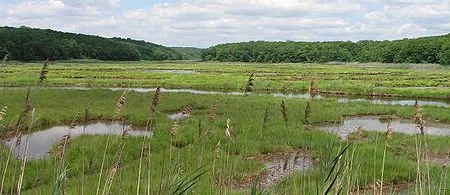
Salt marsh on the Connecticut coast.
Via ecoRI News
As the rate of sea-level rise quickens, a study published in Biological Conservation last November examines the ability of tidal marshes to keep pace. Conducted by the National Estuarine Research Reserve System, this nationwide assessment reveals that marshes along the Pacific Coast appear more likely to survive than those along the Atlantic. Two marshes in southern New England, in Massachusetts and Rhode Island, were found to be the most vulnerable of those evaluated.
Waquoit Bay’s Sage Lot Pond and Narragansett Bay's Nag West are more vulnerable than most along the East Coast.
Research Reserves conducted this study at 16 sites in 13 coastal states. It was based on an approach that evaluated the ability of tidal marshes to thrive as sea levels rise according to five categories of resilience: marsh elevation; change in elevation; sediment supply; tidal range; and rate of sea-level rise.
“This study shows that not all tidal marshes are equally vulnerable to sea-level rise,” Rebecca Roth, executive director of the National Estuarine Research Reserve Association (NERRA), said. “It also gives coastal managers the capacity to understand and compare the ability of marshes to persist in the face of rising seas. This will inform decisions focused on protecting marshes for generations to come.”
Tidal marshes provide many benefits. They protect people and property against storm surges and flooding, improve water quality, and create habitat for fish and wildlife. For millennia, most marshes have kept pace with rising seas by increasing in elevation, according to the 2016 NERRA study.
With sea levels projected to increase much faster in the future, the fate of many marshes is now uncertain. The NERRA says the ability to understand and compare the likelihood of marshes to persist in the face of rising seas can inform strategies to protect them. For example:
Marshes found to be highly resilient are likely to thrive and provide value for a long time; ensuring that they are protected is a good investment for the future.
Moderately resilient marshes can survive if actions are taken to help them thrive, such as reconnecting them to the rivers that nourish them with sediment.
The least resilient may not survive in their current locations; they might be saved through intensive management strategies or by finding opportunities for them migrate to higher ground.