
UNH, NOAA expanding ocean-mapping center
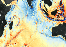
Seafloor map of southern Indian Ocean.
This is from the New England Council (newenglandcouncil.com)
"NEC member the University of New Hampshire (UNH) — in partnership with the National Oceanic and Atmospheric Administration (NOAA) – is expanding its Center for Coastal and Ocean Mapping and Joint Hydrographic Center by adding nine additional labs, offices, and an amphitheater. The joint UNH-NOAA initiative was established in 2000 with the goal of mapping the worldwide ocean floor.
"Students and scientists at the center on UNH’s Durham campus monitor live streams from ships that are collecting data of ocean floor, track fish and whale patterns, and create 3D prototypes. Currently, only 11% of the ocean’s 140 million square mile floor is mapped and internationally, scientists aim to complete a map of the ocean floor in the next thirteen years to ensure ships can safely navigate the ocean by being aware of any potential hazards below them. The center is home to 25 students and scholars from around the world who work with both the private sector and government agencies to achieve that goal.
'''I’ve always wanted to explore the ocean for as long as I can remember. We have better maps of the moon than we do of the ocean,' said UNH student Victoria Dickey during U.S. Rep. Carol Shea-Porter’s recent visit to the center.''
To read more, hit this link.