CRMC

Tim Faulkner: Offshore wind boom continues, with snags

Screen+Shot+2019-06-17+at+6.44.38+AM.png

From ecoRI News (ecori.org)

The demand for offshore wind continues, as the designated wind zones in waters south of Rhode Island, Martha’s Vineyard and Nantucket fill with projects.

At the June 11 meeting of the Rhode Island Coastal Resources Management Council (CRMC), Grover Fugate, executive director, recounted the growing pains to accommodate as much as 22,000 megawatts of offshore wind.

“This industry has literally exploded overnight,” said Fugate, as he highlighted issues confronting several projects.

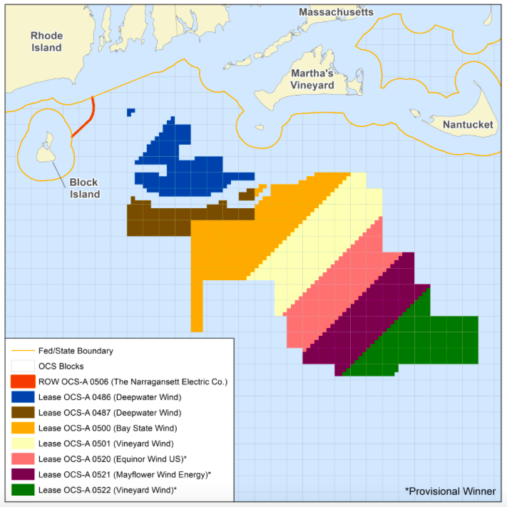
The 800-megawatt Vineyard Wind facility, for instance, is deadlocked with the National Oceanic and Atmospheric Administration (NOAA) over the project’s environmental impact statement.

“That’s not something that’s been done before in the NEPA (National Environmental Policy Act) world,” Fugate said. “So we’re not quite sure where that is going to end up.”

The Nantucket Historical Commission is seeking $16 million from the Vineyard Wind developer, according to Fugate. The island town has sought funds to compensate for adverse visual impacts the 84 turbines may have on tourism.

Connecticut recently announced it wants to add 2,000 megawatts of offshore wind to the power grid but the state lacks approved offshore wind areas.

“Connecticut, of course, does not have any offshore sources,” Fugate said. “The closest ones to Connecticut are us (Rhode Island).”

Connecticut is already signed on for 300 megawatts from the Revolution Wind project located in one of four wind-lease areas that require CRMC approval.

Rhode Island has already signed up 400 megawatts from the same wind project managed jointly by Ørsted US Offshore Wind and the Massachusetts utility Eversource.

Massachusetts has a goal of 3,200 megawatts of offshore wind by 2035. It has already agreed to buy 800 megawatts from the Vineyard Wind project and the state has issued a request for proposal for an addition 800 megawatts that may come from the second half of the Vineyard Wind lease area.

Vineyard Wind went through a lengthy and contentious review for its initial wind facility and wants to meet with CRMC about a review of the second half of its wind-zone lease.

Bay State Wind, another Eversource and Ørsted project, is also moving forward with an 800-megawatt wind project in the same region. Fugate met with Bay State Wind’s CEO and discussed how the project fails to conform with a 1-mile spacing of turbines within its grid configuration.

Fugate said Bay State Wind is using a European design that doesn’t meet the fisheries requirement for U.S. projects.

“So they are taking that back under consideration,” Fugate said.

Vineyard Wind has filed a proposal to deliver 1.2 gigawatts of wind power to New York along a 95-mile transmission line from Vineyard Wind’s second wind zone, in the easternmost section of the federal wind-lease area. In all, New York is looking for some 9,000 megawatts of wind energy.

“If you add it all up it’s about 22,000 megawatts from New York to the Cape that's under consideration,” Fugate said.

He expressed frustration with the federal Bureau of Ocean Energy Management for not requiring an extended analysis of proposed offshore wind project sites.

“If you don't get two years of baseline data you have no way of measuring the impact,” Fugate said. “That may be intentional on their part, I don't know. But we have pushed for baseline data so that you can measure before and after, so that you know what you just did and how to adjust to it. But without that baseline, we don't know what we just did.”

Cable congestion

The surge in offshore wind development has created a need for transmissions lines and onshore connections to the electric grid. Wakefield, Mass.-based Anbaric Development Partners is creating a renewable-energy center on a leased site at the former Brayton Point coal-fired power plant in Somerset, Mass. Anbaric wants to install two high-voltage electric cables from Brayton Point to serve wind facilities off the coast of Massachusetts and Rhode Island. Ørsted would also like to run two cables from its Bay State Wind project to the mainland at Brayton Point.

The transmission lines would run through the the Sakonnet River along the easternmost channel of Narragansett Bay.

Fugate noted that the passage can only accommodate two power cables because of the narrow Stone Bridge corridor between Portsmouth and Tiverton. He said the activity at Brayton Point and other wind-facility operations within Narragansett Bay will be busiest during the summer, causing congestion along the East Passage, which runs between Newport and Jamestown.

“There’s a huge interference with a lot of existing uses down there,” Fugate said.

Federal review

NOAA officials will perform a three-day review of CRMC’s overall coastal program, including a public hearing scheduled for June 18. The review, required every seven years, will culminate with a report of findings that will offer suggested and required actions needed to adhere to federal grant requirements.

In a worst-case scenario, CRMC could face sanctions, which include a loss of federal funding for CRMC’s coastal programs. More than half of CRMC’s budget comes from federal sources.

NOAA’s last evaluation of CRMC was conducted in 2010.

The public hearing will be held at the Department of Administration building, conference room A, One Capital Hill, at 6 p.m.

Matunuck seawall

Hearings are expected in the fall for phase two of a seawall project on Matunuck Beach Road, in South Kingstown, R.I. The first phase was a highly controversial and meaningful case for the CRMC, as it confronts sea-level rise and shoreline erosion from climate change.

Tim Faulkner is an ecoRI News journalist.


Frank Carini: Newport Dinner Train cited for herbicide use

The Newport Dinner Train back in 2009.

The Newport Dinner Train back in 2009.

From ecoRI News (ecori.org)

PORTSMOUTH, R.I.

Last fall the Newport & Narragansett Bay Railroad Co. was cited by the Rhode Island Coastal Resources Management Council for spraying herbicide within 200 feet of coastal features without approval.

The unauthorized spraying of poison by the North Kingstown-based operation, which runs the Newport Dinner Train, along railroad tracks that run along the West Passage of Narragansett Bay, including through coastal wetlands and people’s backyards, caused “vegetative alterations,” according to the Coastal Resources Management Council (CRMC).

The spraying was in violation of the Rhode Island Coastal Resources Management Program, which notes that the indiscriminate use of herbicides or the clear-cutting of vegetation is prohibited.

The Sept. 20, 2018 notice of violation noted that failure to comply would result in a cease-and-desist order.

In January, a railroad representative signed a consent agreement, agreeing to clean up the dead vegetation from the rail corridor over the winter. The Newport & Narragansett Bay Railroad Co. paid an administrative fine of $250, which is common practice when a violator agrees to sign a consent agreement to resolve a violation.

It was also agreed that the company would submit a long-term vegetation management plan, as company officials told CRMC that regular maintenance of the vegetation would be needed.

The deadline for the company’s vegetation plan was March 30. As of April 1, no plan had been received, according to a CRMC official. She said enforcement will likely do a site inspection this week to see if the company is in compliance.

“Buffer zones along the perimeter of coastal water bodies can be effective in trapping sediments, pollutants … and absorbing nutrients (particularly nitrogen) from surface water runoff and groundwater flow,” according to CRMC. “The effectiveness of vegetated buffers as a best management practice for the control of nonpoint source runoff is dependent upon their ability to reduce the velocity of runoff flow to allow for the deposition of sediments, and the filtration and biological removal of nutrients.”

Coastal buffer zones also provide habitat for native plants and animals.

“Vegetation within a buffer zone provides cover from predation and climate, and habitat for nesting and feeding by resident and migratory species,” according to CRMC. “Some species which use coastal buffer zones are now relatively uncommon, while others are considered rare, threatened or endangered. These plants and animals are essential to the preservation of Rhode Island’s valuable coastal ecosystem.”

Frank Carini is editor of ecoRI News.


Tim Faulkner: Projected sea-level rise looks scarier

Via ecoRI News (ecori.org)

A stitch in time saves nine. A cat has nine lives. Baseball legend Ted Williams wore No. 9. Unfortunately for Rhode Island, nine is also the new number for the feet of projected sea-level rise.

Just a few years ago, the upper estimate for sea-level rise was 3 feet. More recently, it was 6.6 feet. But a recent assessment by the National Oceanic and Atmospheric Administration (NOAA) projects sea-level rise to increase in Rhode Island by 9 feet, 10 inches by 2100.

“To put in perspective we’ve had 10 inches (of sea-level rise) during the last 90 years. We’re about to have 10 feet in the next 80 years,” said Grover Fugate, executive director of Rhode Island’s Coastal Resources Management Council (CRMC).

Fugate made the remarks during a recent environmental business roundtable featuring the state’s top energy and environment officials: Fugate; Janet Coit, executive director of the Department of Environmental Management; and Carol Grant, commissioner of the Office of Energy Resources.

Coit and Grant highlighted the positive trends in Rhode Island's “green economy,” such as growth in renewable energy and the fishing industry. Fugate spoke last and, referring to himself as the “Debbie Downer” of the meeting, straightaway delivered the bad news facing the state from climate change.

“I’ve been director here for 31 years and the numbers we are seeing are staggering to me,” Fugate said of the NOAA report. “The changes we are going to see to our shoreline are profound, dramatic, and there is going to be a lot of economic adjustment going forward."

The major upward revision in sea level-rise projections, he said, will be transformative to life in Rhode Island, particularly along the coastal region of Washington County and much of Bristol County and Warwick.

To drive the point home, Fugate showed photographs of severe beach erosion along Matunuck Beach in South Kingstown. The shoreline there has been eroding at a clip of 4 feet annually since the 1990s. Recently, the rate climbed to 8 feet a year. That level was calculated before NOAA released the latest projected increase in sea-level rise.

Higher seas, Fugate said, create a multiplier effect that intensifies coastal erosion and flooding. Tides and storm surges reach further inland. Climate change also produces stronger wind and rain events. Thus, a storm classified as a 50-year event can cause the same damage as a 100-year event, according to Fugate.

The recent NOAA report says the principal cause for higher seas is the melting of land-based ice sheets in Greenland and Antarctica. Since 2009, the region from Virginia north to the Canadian Maritime Provinces has experienced accelerated sea-level rise due to changing ocean currents in the Gulf Stream. NOAA expects that trend to continue.

According to the report, the impact of prolonged sea-level rise will be loss of life, damage to infrastructure and the built environment, permanent loss of land, ecological transformation of coastal wetlands and estuaries, and water-quality impairment.

Those impacts, Fugate said, are already here and being felt. He showed slides of storm drains flowing backwards and flooding parking lots during regular high tides, and buildings that are becoming islands. Coit noted that wetlands and marshes are essentially drowning in this higher water.

“The future is here now,” Fugate said. “It’s here and we are seeing profound changes.”

To combat climate change, coastal buildings are being elevated thanks to federal incentives. The CRMC also has permissive policies that allow for the rebuilding of sea walls damaged by these more forceful storms and accelerated erosion.

Several environmental engineers and municipal planners at the recent meeting raised questions about the need for policies and regulations to address threatened infrastructure, such as septic systems, utilities, and spoke about the risk of inland river flooding. Their queries suggested that the state is taking a piecemeal approach to a vast problem.

The environmental group Save The Bay has criticized an Army Corps of Engineers plan to provide funding to elevate homes along the Rhode Island coast from Westerly to Narragansett, R.I. Fugate said that plan has flaws, but endorses the concept as the best solution for protecting property owners.

Save The Bay, however, wants greater consideration given to migration away from the coast. Retreat from a receding shoreline, it argues, protects people, as well as the ecological health and resilience of the natural resource that defines the Ocean State.

“Are we going to elevate homes that can’t be reached because the roads are under water?” asked Topher Hamblett, Save The Bay’s policy director. “I think the state needs a long-term strategy about moving back from the coast.”

Hamblett portended that coastal retreat would greatly impact the real-estate market and present enormous challenges for policymakers and elected officials.

“But this is so big on so many levels that unless and until we start really seriously planning to move back out of harms way, we are going to inflict a lot of otherwise avoidable damage on ourselves,” Hamblett said.

Fugate and Coit said elevating buildings may not be the best option, but it's the only one currently with funding. If approved, it would provide about $60 million of federal relief money apportioned after Hurricane Sandy.

“Yes, the money would be better spent in another way,” Coit said. “Could we protect more land on the shore and in the flood plains? Could we help people move out all together through a buy-out program? Could we look at infrastructure that helps the whole public instead of the individual homeowner?”

Fugate said the problem is compounded by federal flood-insurance maps that created immense controversy in 2013, when the Federal Emergency Management Agency released inaccurate flood-zone maps. Those maps led to astronomically high insurance premiums for some and rampant confusion among others living on or near the water.

Fortunately, Fugate said, the CRMC and the University of Rhode Island have designed interactive maps forecasting the impacts of sea-level rise, coastal flooding and storm surge. The modeling behind those maps is helping remedy the flood-map problem. Nevertheless, Fugate encouraged anyone with property in a flood zone to buy flood insurance.

Coit said the state is in a good position to address sea-level rise and climate change by following the same model that led to the development of the Block Island Wind Farm. The Ocean Special Area Management Plan (Ocean SAMP) brought together federal, local and private stakeholders to craft a plan for mapping out public and private uses for offshore regions. CRMC is working on a similar Shoreline SAMP to address long-term coastal planning.

Coit said the state Executive Climate Change Coordinating Council (EC4) is already addressing comprehensive climate-change planning for the state. The EC4 recently released an assessment of Rhode Island's greenhouse gas-emissions reduction plan. It’s now scrutinizing flooding at wastewater treatment facilities, among other threats from climate change.

“I think we are in a good place for Rhode Island to really look holistically at a resiliency and adaptation plan that takes into account all of the issues,” Coit said.

Most of the EC4’s funding comes from the Environmental Protection Agency. CRMC gets half of its budget from the Department of Commerce. But Coit, Grant and Fugate say President Trump’s hostility toward climate change won’t curtail state planning efforts, much less the realities of sea-level rise and global warming.

While the NOAA report doesn’t offer its own solutions, it concludes that sea-level rise is unrelenting.

“Even if society sharply reduces emissions in the coming decades, sea level will most likely continue to rise for centuries,” according to NOAA.

Tim Faulkner writes for ecoRI News.

Welfare for the rich? In R.I., Feds probably will pay people to elevate coastal houses

By TIM FAULKNER for ecoRI News 

Homes and business across the southern shore of Rhode Island will likely be offered money to elevate their houses and buildings to protect against sea-level rise and flooding from coastal storms.

In all, 341 structures between Westerly and Narragansett were identified by the Army Corps of Engineers for its fortification program. The study concluded that buying out or moving the buildings was too expensive to warrant funding.

“It’s not cheap to pick up a house and move it,” said Christopher Hatfield, project manager for the Army Corps office in Concord, Mass.

Grover Fugate, executive director of the  Rhode Island Coastal Management Council (CRMC), said the Army Corps estimates on sea-level rise are too conservative and therefore wants more buildings to qualify for the adaptation program.

“We believe there could be more houses eligible for that project,” Fugate said.

The Army Corps estimates that sea level will rise 4.44 inches in the next 50 years. Fugate defers to the more recent estimates by the National Oceanic and Atmospheric Administration (NOAA) of 2 feet by 2050 and up to 7 feet by 2100.

Hatfield said time constraints of about 18 months prevented the study from using more recent data on sea-level rise.

“We went with what we had and did the best modeling we could and that’s what your seeing in the report,” Hatfield said.

Fugate said the project is nonetheless warranted because, “it will obviously improve the survivability of those structures ... it will reduce their flood insurance.”

Flood insurance rates, he said, are expected to rise significantly, as the federal program reduces its subsidies. Fugate said he has been working with Gov. Gina Raimondo to help lower local flood-insurance costs in the state.

The public is being asked to provide feedback on the program through Nov. 21. Property owners along the 28-mile stretch of shoreline must reach out to the Army Corps to find out if they own one of the targeted buildings. If so, and the program is approved, the Army Corps will offer to pay 65 percent of the cost to elevate the home or building. The property owner must pay the remaining 35 percent. Participation is voluntary. Fugate said the state may offer no-interest or low-interest loans to help property owners pay their share.

Most of the targeted Rhode Island structures are homes. Depending on the location, the building will be elevated between 12 and 18 feet. An additional 46 at-risk buildings, mostly commercial structures, aren't suited for elevation but will be eligible for other flood-protection measures, according to the Army Corps. Tide walls and flood gates were considered for parts of Westerly and Narragansett, but were deemed too costly.

The CRMC was one of 15 Rhode Island agencies and environmental groups to coordinate with the Army Corps on the study. The study’s $800,000 cost was funded through the federal Disaster Relief Appropriations Act of 2013 for Hurricane Sandy impacts. A more detailed study from the Army Corps will examine other issues such as what happens to the septic systems of the homes being elevated, according to CRMC.

The Army Corps examined 4,000 properties, valued at $600 million, along the shoreline in Washington County. The cost to elevate the 341 structures is estimated at $58 million.

The large-scale coastal threat adaptation program is one of the first of its kind in the country. Similar studies are underway in Virginia and Maryland. Some 2,500 homes affected by Hurricane Katrina are undergoing similar construction projects.

Buildings on Narragansett Bay may also be considered for a future project, but Hatfield said the result might be different because the southern region has a higher risk of erosion from storms and sea-level rise.

“It doesn’t mean we’ll end up with the same recommendations," he said. "These communities are very different than those along the south coast."

Unless there is public demand, there are no plans for hearings on the proposal. Any feedback or questions should go to Christopher Hatfield, of the Army Corps New England District, via e-mail at cenae-ep@usace.army.mil or by calling 978-318-8520.