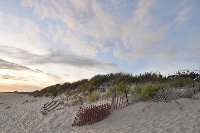
Dunes on Napatree Point
WESTERLY, R.I.
In late October 2012, about a day after Superstorm Sandy’s initial surge battered much of southern New England’s coast, especially its open-ocean shoreline, Janice Sassi navigated her way through a parking lot here filled with “mountains of mud” to find a “moonscape.”
“The dunes were completely flat,” recalled Sassi, manager of the 86-acre Napatree Point Conservation Area. “I thought it was done. It looked like one big beach.”
Sandy had ripped chunks of beachgrass from sections, and one area was forced back some 30 feet. At that moment and for days after, Sassi was concerned about Napatree Point’s future.
Her friend Peter August, a now-retired University of Rhode Island professor and a Napatree Point science adviser, put her racing mind at ease. The former director of URI’s Coastal Institute told her the resilient peninsula that offers sweeping views of Little Narragansett Bay, Block Island Sound, and New York’s Fishers Island would be fine. He reminded her that Napatree Point had previously survived one of the most destructive and powerful hurricanes in recorded history.
The hurricane of 1938, also known as the “Great New England Hurricane,” smashed the peninsula’s 39 2- and 3-story houses that stood just a few feet from the churned-up fury of the Atlantic Ocean. The 3- to 4-foot-high wall in front of those summer homes did nothing to prevent their destruction.
Storm waves broke over roofs and plowed “through the cement seawall as if it were transparent,” R.A. Scotti wrote in her 2003 book, Sudden Sea: The Great Hurricane of 1938.
“If you build on a barrier beach, you are toying with nature,” she wrote.
On the other side of the Napatree Point peninsula, most if not all of the private docks that extended into Little Narragansett Bay were reduced to kindling. Some residents waited out the 100-year storm in the remains of decommissioned Fort Mansfield. Fifteen people died.
The historic ’38 storm, much more so than Superstorm Sandy nine years ago, pummeled the 1.5-mile-long, sand-swept peninsula that curves away from the affluent village of Watch Hill. It severed the connection to Sandy Point, now a mile-long island shared by Rhode Island and Connecticut. In the eight decades since Sandy Point was left afloat, the island has drifted one and a half miles to the north.
More than a century earlier, Napatree Point, which was then densely forested — its name reportedly derives from nap or nape (neck) of trees — was significantly altered by another hurricane. The Great September Gale of 1815 “wiped it clean” and no tree has grown there since, according to Scotti’s book.
Following the hurricane of 1815, Napatree Point was significantly developed, and saw the construction of a boarding house and a hotel. By the end of the century, construction of Fort Mansfield had begun.
Though Sassi, then less than three years into her job after a career in law enforcement, was initially skeptical of August’s reassurances that her beloved Napatree Point would rebound, she’s thankful it did. She said it took about five years for the conservation area to completely repair itself. The beachgrass regrew, and the dunes regained their elevation.
Napatree Point was able to heal itself because humans have given it room to breathe. After the ’38 hurricane, one of the most financially destructive storms on record, developers looking to rebuild the summer cottages and construct other structures were rebuffed.
With no roads, homes, and hardened structures obstructing Mother Nature, Napatree Point has been allowed to change with the times. August noted that the barrier beach has the space to continually wash back over itself.
“It doesn’t erode away. It just moves,” said August, who founded URI’s Environmental Data Center three decades ago. “Napatree Point was 80 acres when the hurricane of ’38 struck; it’s 80 acres now, just in a different place. Napatree Point will always be here. It rolls with the punches. It gets changed but still exists.”
The Hope Valley resident said the geology of Napatree Point is a perfect example of how a barrier dune ecosystem works naturally. He explained that when Napatree Point is hit by big storms, such as the Great New England Hurricane or Superstorm Sandy, and wave action and tidal surge punch through the dunes, it creates wash-over fans on the backside, meaning the position of the peninsula’s dunes change; they aren’t lost.
“They’re rolling over themselves and they can do that because we’re letting the sand go where the sand wants to go,” August said.
Napatree Point is owned, managed and protected by a partnership of different interests: the Watch Hill Fire District, the Watch Hill Conservancy, which employs Sassi, the Town of Westerly, the state, and a few private landowners. Conservation easements protect it from future development.
In the summer, this slender strip of land — the average width is 517 feet — at the mouth of Little Narragansett Bay, where the Pawcatuck River empties into Block Island Sound, is overrun with tourists, boaters, beachgoers, hikers, anglers and nature observers. Finding a scrap of beach can be difficult, and some areas are roped off for important visitors, most notably piping plovers and American oystercatchers, both of which nest in the sand.
Sassi is thrilled that Napatree Point is so popular, but all the human visitors have an accumulating impact on the peninsula’s delicate dune system. The West Warwick, R.I., resident noted that the fact there is no development makes it easier for the small peninsula to defend itself from a changing climate and human intrusion.
The conservation area, however, isn’t immune to sea-level rise and other stressors associated with the climate crisis. About three years ago, Sassi and August began noticing that the entrance to Napatree Point, through a large parking lot off Bay Street that is lined with boutique shops and a mix of culinary options, began to flood during extremely high tides.
It’s now beginning to flood even during normal high tides. As sea levels rise and more frequent flooding occurs, access to the peninsula, at least via land, will become more and more restricted unless something is done. August said plans are underway to elevate the entrance, which laps up against Watch Hill Harbor.
Napatree Point is a barrier beach that has been shaped and reshaped by storms, sometimes profoundly, as was the case 206 years ago, 83 years ago, and nine years ago. The peninsula is composed of more sand than soil and its shoreline is worked upon daily by ocean waves and the tide. Like most barrier beaches, especially those with no human-made structures, Napatree Point is constantly in a state of flux. Since 1939, it has shifted north, toward Little Narragansett Bay, some 200 feet, according to mapping by the Coastal Resources Management Council.
The peninsula, however, is much more than a summer destination and a birdwatcher’s paradise. It’s also a habitat provider and a storm protector.
This fragile yet pliable barrier beach helps protect Westerly’s mainland. And to help protect Napatree Point’s dynamic ecosystem — and, thus, tourist-friendly Watch Hill — from storm surge, coastal erosion, and human visitors, a number of restoration projects have been undertaken.
During the past dozen years, some 4,000 native plants, such as seaside goldenrod, beach plum, swamp milkweed and groundseltree, have been added to help anchor Napatree Point’s shifting sands — their dense root mats keep erosion in check — and to attract pollinators.
Split-rail fences have been erected and signs posted to keep visitors and their wheeled coolers from making their own paths from the peninsula’s protected side to its open-ocean side. At one point several years ago, 50 crossover paths had been plodded through Napatree Point’s dunes and vegetation. Dinghies and Zodiacs land on the Little Narragansett Bay/Watch Hill Harbor side, before their occupants traverse the peninsula to the Atlantic Ocean side, where they lie in the sun, swim, and bodysurf.\
This tireless restoration work piloted by Sassi, August, Hope Leeson, Bryan Oakley and others has made Napatree Point a national model for stewardship, an important distinction since the area caters to an abundance of life, including mussel beds, bats, minks, foxes, deer, monarch butterflies, and a plethora of birds.
Off its coast are some of the biggest and healthiest eelgrass beds in Rhode Island waters. These vital marine ecosystems provide foraging areas and shelter to young fish and invertebrates, spawning surfaces for sea life, and food for migratory waterfowl. Gray and harbor seals hang out on the open-ocean side of the peninsula. In the winter, rafts of sea ducks are a common sight in the waters off the peninsula.
The Audubon Society has recognized Napatree Point as a globally important bird area. Veteran Rhode Island birder Rey Larsen has identified more than 300 different species of birds on the sandy, wind-swept peninsula.
The Napatree Point lagoon, about 3.5 feet deep in the middle, is home to a half-dozen different kinds of fish, including the American eel. It’s also an important horseshoe-crab nursery. The entrance to the 10-acre lagoon, from Little Narragansett Bay, is the peninsula’s most rapidly changing part, according to August. He said the entrance to the lagoon has moved a few times during the past decade alone.
Napatree Point, unlike much of Rhode Island’s built-up coastline, is better positioned to handle the climate crisis because humans are allowing its sands to shift naturally.
“The most important thing we can do is get people excited about Napatree Point so they want to protect it,” Sassi said.
For a wealth of science, stewardship, and monitoring information about the Napatree Point Conservation Area, click here.
Frank Carini is editor of ecoRI News.
Watch Hill and Watch Hill Cove from the eastern end of Napatree Point


